1900s (20th Century) Maps of Sioux Falls, South Dakota
Explore 11 historic maps of Sioux Falls from the 1900s (20th Century). These maps offer a rare glimpse into what life looked like during the 1900s — showing old roads, neighborhoods, homes, and landmarks that have changed or disappeared over time.
Whether you're researching your family's past, planning a metal detecting trip, or studying how Sioux Falls's landscape evolved across the 1900s, these high-resolution maps are a powerful tool for exploring the history of this region.
- Focus on a specific era: All maps on this page are from the 1900s, giving you a focused view of this time period.
- See what’s changed: Compare century-old streets, trails, and buildings to today's modern landscape using overlays and satellite layers.
- Research with precision: Use these maps for genealogy, historical research, land use analysis, or educational projects.
- View, download, or print: Maps are fully viewable online in high resolution, and can be downloaded or printed for your own records.
Start exploring Sioux Falls's history through authentic maps from the 1900s. This is your window into the past.
Sioux Falls, SD maps
(11)- 1900 Map of Canton
 1900 Canton1900 Print · USGSSoutheastern South Dakota and the Iowa borderlands are captured here at a peak of late-nineteenth-century rail expansion. Genealogists can trace the early foundations of towns like Canton, Centerville, and Beresford along the Big Sioux River.2 unique versions available
 - 1955 Map of Sioux Falls, 1967 Print
 1955 Sioux Falls1967 Print · USGSThe eastern South Dakota and western Minnesota borderlands come alive in the mid-fifties, showing the vital rail-to-river connections of the era. Genealogists can trace family footprints across townships like Madison and Pipestone, while following the paths of the Big Sioux River and the Chicago and North Western line.3 unique versions available
 - 1958 Map of Sioux Falls
 1958 Sioux Falls1958 Print · USGSThe tri-state borderlands of South Dakota, Minnesota, and Iowa are captured here during the mid-century peak of the regional rail network. Genealogists and historians can trace local landmarks like Augustana Academy, the St Marys Cem, and the path of the Illinois Central through Rock Rapids.
 - 1962 Map of Harrisburg, 1964 Print
 1962 Harrisburg1964 Print · USGSHarrisburg and the surrounding Lincoln County townships are captured in the early 1960s, showing a prairie landscape still defined by rail lines and rural school districts. Researchers can find long-standing local landmarks like Pleasant View Cem, various country schoolhouses including Shindler Sch, and the recreation grounds at Lake Alvin.
 - 1962 Map of Brandon, 1964 Print
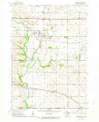 1962 Brandon1964 Print · USGSThe South Dakota and Iowa borderlands come to life in this early sixties survey of the Big Sioux River valley. Genealogists and historians can trace the early layouts of Brandon and Rowena, or locate family sites at Beaver Valley Ch and local Quarries.2 unique versions available
 - 1962 Map of Sioux Falls East, 1964 Print
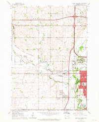
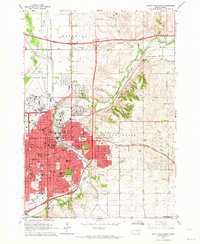 1962 Sioux Falls East1964 Print · USGSMid-century Minnehaha County is captured during a period of significant growth as new interstates reach the city. Genealogists can trace family roots through numerous sites like Woodlawn Cemetery, Augustana College, and the State Prison Farm.3 unique versions available
 - 1962 Map of Tea, 1964 Print
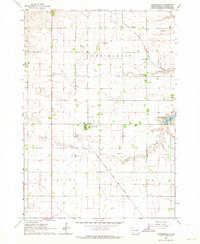
 1962 Tea1964 Print · USGSThe rural landscape of Lincoln County appears in the early sixties as a network of section roads and small-town commerce. Researchers can trace the heritage of local school districts at Dewey School and Rader School or follow the tracks of the Great Northern railroad.2 unique versions available
 - 1962 Map of Sioux Falls West, 1964 Print
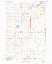
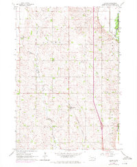
 1962 Sioux Falls West1964 Print · USGSThe western edge of Sioux Falls was rapidly evolving in the early sixties as infrastructure expanded across the South Dakota prairie. Researchers can trace the development of suburban institutions like O'Gorman High Sch or locate rural landmarks such as Bethel Cem and Ellis.3 unique versions available
 - 1962 Map of Crooks, 1970 Print
 1962 Crooks1970 Print · USGSMinnehaha County's agricultural heartland is captured here in the early sixties, showing the rural landscape around Lyons and Crooks. Genealogists and local historians can trace family roots through landmarks like Lyons Cem, West Nidaros Ch, and the Burlington Northern rail line.2 unique versions available
 - 1985 Map of Sioux Falls
 1985 Sioux Falls1985 Print · USGSIn the mid-1980s, the borderlands of South Dakota, Minnesota, and Iowa reveal a landscape shaped by the Big Sioux River and a growing urban hub. Researchers can trace the development of Sioux Falls and locate smaller communities like Dell Rapids, Garretson, and Valley Springs.2 unique versions available
 - 1985 Map of Rock Rapids
 1985 Rock Rapids1985 Print · USGSThe borderlands of South Dakota and Iowa come into focus in the mid-1980s, centered on the fertile valleys of the Big Sioux River. Genealogists and researchers can trace rural homesteads near Rock Rapids, find Dordt College in Sioux Center, or locate old burial sites like Grace Hill Cem.2 unique versions available
End of results
Showing maps 1-11 of 11
Top cities near Sioux Falls
- Brandon historical maps
- Harrisburg historical maps
- Tea historical maps
- Hartford historical maps
- Lennox historical maps
- Crooks historical maps
See more
Top neighborhoods of Sioux Falls
Frequently asked questions
- What are the different types of historical maps available for Sioux Falls?
- What is the oldest map of Sioux Falls?
- Where can I purchase historical maps of Sioux Falls for my home or office?
- Where can I download high-res historical maps of Sioux Falls?
- Are there historical topographic maps available for Sioux Falls?
- Is there historical aerial imagery available for Sioux Falls?
- Where are historical maps of Sioux Falls sourced from?