1960s Maps of Oglala, South Dakota
Explore 7 historic maps of Oglala from the 1960s. These maps offer a rare glimpse into what life looked like during the 1960s — showing old roads, neighborhoods, homes, and landmarks that have changed or disappeared over time.
Whether you're researching your family's past, planning a metal detecting trip, or studying how Oglala's landscape evolved across the 1960s, these high-resolution maps are a powerful tool for exploring the history of this region.
- Focus on a specific era: All maps on this page are from the 1960s, giving you a focused view of this time period.
- See what’s changed: Compare century-old streets, trails, and buildings to today's modern landscape using overlays and satellite layers.
- Research with precision: Use these maps for genealogy, historical research, land use analysis, or educational projects.
- View, download, or print: Maps are fully viewable online in high resolution, and can be downloaded or printed for your own records.
Start exploring Oglala's history through authentic maps from the 1960s. This is your window into the past.
Oglala, SD maps
(7)- 1967 Map of Pine Ridge NE, 1969 Print
 1967 Pine Ridge NE1969 Print · USGSThe ranchlands of Shannon County are captured here in the late sixties as the Missouri River Basin development program shaped the landscape. Genealogists and historians can trace the Cooms Ranch homestead and the remote Landing Strip along Little Grass Creek.
 - 1967 Map of Slim Butte NW, 1969 Print
 1967 Slim Butte NW1969 Print · USGSShannon County in the late sixties reveals a landscape of winding drainages and rural outposts. Researchers can locate the isolated Swallow Ch and trace the paths of Blacktail Creek and Slim Butte Creek through this Missouri River Basin study.
 - 1967 Map of Manderson, 1969 Print
 1967 Manderson1969 Print · USGSManderson and the surrounding South Dakota prairie are documented here during the late sixties, centered on the Wounded Knee Creek valley. Genealogists and local historians can locate St Paul Cem and trace the paths of White Horse Creek and Pepper Creek.
 - 1967 Map of Oglala, 1969 Print
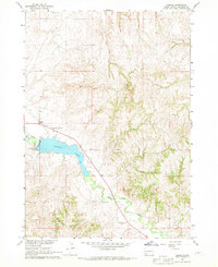 1967 Oglala1969 Print · USGSThe Pine Ridge reservation area in the late sixties reveals a landscape shaped by water and community faith. Genealogists and local historians can trace landmarks like Our Lady of The Sioux Ch, St James Cem, and the waters of White Clay Creek.
 - 1967 Map of Slim Butte NE, 1970 Print
 1967 Slim Butte NE1970 Print · USGSThe Oglala Lakota plains are documented in the late sixties, showing a landscape shaped by the winding White River. Researchers can locate community centers like the Oglala Sch, Makasan Ch, and family landmarks near Slim Butte.
 - 1967 Map of Willow Creek SW, 1970 Print
 1967 Willow Creek SW1970 Print · USGSShannon County, South Dakota, is captured in the late sixties as part of the Missouri River Basin development study. Researchers can trace the rugged drainage of Cedar Bluff Creek and the prominent terrain of Cedar Bluffs across this open landscape.
 - 1967 Map of Willow Creek, 1970 Print
 1967 Willow Creek1970 Print · USGSShannon County in the late sixties shows a landscape shaped by the White River and its intricate creek systems. Genealogists and local historians can locate Our Lady of Good Council Ch, St John Chapel, and the prominent Cedar Bluff.
End of results
Showing maps 1-7 of 7
Top neighborhoods of Oglala
Frequently asked questions
- What are the different types of historical maps available for Oglala?
- What is the oldest map of Oglala?
- Where can I purchase historical maps of Oglala for my home or office?
- Where can I download high-res historical maps of Oglala?
- Are there historical topographic maps available for Oglala?
- Is there historical aerial imagery available for Oglala?
- Where are historical maps of Oglala sourced from?