1900s (20th Century) Maps of Canyon Springs Preserve, Pennington County
Explore 5 historic maps of Canyon Springs Preserve from the 1900s (20th Century). These maps offer a rare glimpse into what life looked like during the 1900s — showing old roads, neighborhoods, homes, and landmarks that have changed or disappeared over time.
Whether you're researching your family's past, planning a metal detecting trip, or studying how Canyon Springs Preserve's landscape evolved across the 1900s, these high-resolution maps are a powerful tool for exploring the history of this region.
- Focus on a specific era: All maps on this page are from the 1900s, giving you a focused view of this time period.
- See what’s changed: Compare century-old streets, trails, and buildings to today's modern landscape using overlays and satellite layers.
- Research with precision: Use these maps for genealogy, historical research, land use analysis, or educational projects.
- View, download, or print: Maps are fully viewable online in high resolution, and can be downloaded or printed for your own records.
Start exploring Canyon Springs Preserve's history through authentic maps from the 1900s. This is your window into the past.
Canyon Springs Preserve, Pennington County maps
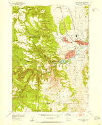
(5)- 1903 Map of Rapid
 1903 Rapid1903 Print · USGSThe Black Hills transition from mountains to plains at the turn of the century, centered on the growing rail hub of Rapid. Researchers can trace the early rail corridor of the Fremont Elkhorn and Missouri Valley through Fort Meade and Piedmont.4 unique versions available
 - 1953 Map of Rapid City West, 1955 Print
 1953 Rapid City West1955 Print · USGSRapid City was evolving from a Black Hills gateway into a modern regional center during the early fifties. Genealogists and historians can trace institutional roots at the Sioux Sanatorium or locate rural landmarks like Whispering Pine Sett and Red Brick Sch.4 unique versions available
 - 1953 Map of Rapid City, 1964 Print
 1953 Rapid City1964 Print · USGSWestern South Dakota's transition from the Black Hills to the open prairie is captured here during the mid-fifties. Researchers can trace the development of Ellsworth Air Force Base alongside historic landmarks like Bear Butte and the Lower Alkali School.3 unique versions available
 - 1954 Map of Pactola Dam, 1955 Print
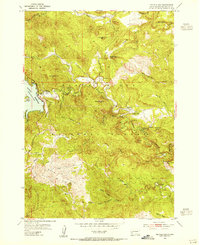 1954 Pactola Dam1955 Print · USGSThe Black Hills landscape undergoes a major transformation in the mid-1950s as the Pactola Reservoir takes shape. Genealogists and historians can locate early mountain camps like Placerville Camp and Hisega, or trace the path of the Abandoned Flume along Rapid Creek.6 unique versions available
 - 1957 Map of Rapid City
 1957 Rapid City1957 Print · USGSWestern South Dakota in the mid-fifties reveals a landscape of high-altitude forests and growing military installations. Researchers can trace the development of Ellsworth Air Force Base, locate the Theodore Roosevelt Monument, and find rural landmarks like Lower Alkali School.
End of results
Showing maps 1-5 of 5
Frequently asked questions
- What are the different types of historical maps available for Canyon Springs Preserve?
- What is the oldest map of Canyon Springs Preserve?
- Where can I purchase historical maps of Canyon Springs Preserve for my home or office?
- Where can I download high-res historical maps of Canyon Springs Preserve?
- Are there historical topographic maps available for Canyon Springs Preserve?
- Is there historical aerial imagery available for Canyon Springs Preserve?
- Where are historical maps of Canyon Springs Preserve sourced from?