1930s Maps of Fish Springs, Tennessee
Explore 3 historic maps of Fish Springs from the 1930s. These maps offer a rare glimpse into what life looked like during the 1930s — showing old roads, neighborhoods, homes, and landmarks that have changed or disappeared over time.
Whether you're researching your family's past, planning a metal detecting trip, or studying how Fish Springs's landscape evolved across the 1930s, these high-resolution maps are a powerful tool for exploring the history of this region.
- Focus on a specific era: All maps on this page are from the 1930s, giving you a focused view of this time period.
- See what’s changed: Compare century-old streets, trails, and buildings to today's modern landscape using overlays and satellite layers.
- Research with precision: Use these maps for genealogy, historical research, land use analysis, or educational projects.
- View, download, or print: Maps are fully viewable online in high resolution, and can be downloaded or printed for your own records.
Start exploring Fish Springs's history through authentic maps from the 1930s. This is your window into the past.
Fish Springs, TN maps
(3)- 1935 Map of Watauga Valley
 1935 Watauga Valley1935 Print · USGSUpper East Tennessee's river valleys and mountain ridges are documented here during the mid-thirties, centered on the growing industrial hub of Elizabethton. Researchers can locate numerous vanished landmarks, from the Manganese Mine to rural schoolhouses like Caldwell Springs Sch.
 - 1935 Map of Fish Springs
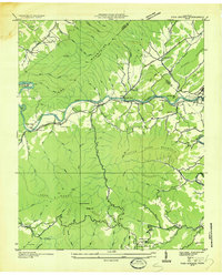 1935 Fish Springs1935 Print · USGSNortheast Tennessee in the mid-1930s was a landscape of steep mountain ridges and river-valley settlements on the eve of significant TVA changes. Researchers can trace the path of the SOUTHERN RAILWAY through Fish Springs, find remote schools like Horseshoe Sch, and locate industrial landmarks such as the LIME KILN.
 - 1938 Map of Fish Springs
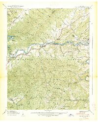 1938 Fish Springs1938 Print · USGSThe Watauga River valley in East Tennessee is shown here in the late 1930s, featuring the winding Southern Railway and the original townsite of Butler. Local historians can trace family-named landmarks and rural hubs like Fish Springs and Campbell Chapel.2 unique versions available
End of results
Showing maps 1-3 of 3
Top cities near Fish Springs
- Bristol historical maps
- Elizabethton historical maps
- Unicoi historical maps
- Walnut Hill historical maps
- Central historical maps
- Bluff City historical maps
See more
Frequently asked questions
- What are the different types of historical maps available for Fish Springs?
- What is the oldest map of Fish Springs?
- Where can I purchase historical maps of Fish Springs for my home or office?
- Where can I download high-res historical maps of Fish Springs?
- Are there historical topographic maps available for Fish Springs?
- Is there historical aerial imagery available for Fish Springs?
- Where are historical maps of Fish Springs sourced from?