1960s Maps of Cherry Crossroads, Tennessee
Explore 1 historic maps of Cherry Crossroads from the 1960s. These maps offer a rare glimpse into what life looked like during the 1960s — showing old roads, neighborhoods, homes, and landmarks that have changed or disappeared over time.
Whether you're researching your family's past, planning a metal detecting trip, or studying how Cherry Crossroads's landscape evolved across the 1960s, these high-resolution maps are a powerful tool for exploring the history of this region.
- Focus on a specific era: All maps on this page are from the 1960s, giving you a focused view of this time period.
- See what’s changed: Compare century-old streets, trails, and buildings to today's modern landscape using overlays and satellite layers.
- Research with precision: Use these maps for genealogy, historical research, land use analysis, or educational projects.
- View, download, or print: Maps are fully viewable online in high resolution, and can be downloaded or printed for your own records.
Start exploring Cherry Crossroads's history through authentic maps from the 1960s. This is your window into the past.
Cherry Crossroads, TN maps
(1)- 1968 Map of Union Hill, 1971 Print
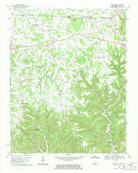 1968 Union Hill1971 Print · USGSThe Tennessee and Kentucky borderlands near Clay County come to life in this late-1960s survey of upland settlements and winding creek forks. Researchers can trace family sites and community landmarks like Miles Crossroads, Clementsville, and the Mt Vernon Sch.
End of results
Showing maps 1-1 of 1
Top cities near Cherry Crossroads
- Tompkinsville historical maps
- Celina historical maps
- Red Boiling Springs historical maps
- Gainesboro historical maps
- Gamaliel historical maps
- Fountain Run historical maps
Frequently asked questions
- What are the different types of historical maps available for Cherry Crossroads?
- What is the oldest map of Cherry Crossroads?
- Where can I purchase historical maps of Cherry Crossroads for my home or office?
- Where can I download high-res historical maps of Cherry Crossroads?
- Are there historical topographic maps available for Cherry Crossroads?
- Is there historical aerial imagery available for Cherry Crossroads?
- Where are historical maps of Cherry Crossroads sourced from?