1930s Maps of Cosby, Tennessee
Explore 2 historic maps of Cosby from the 1930s. These maps offer a rare glimpse into what life looked like during the 1930s — showing old roads, neighborhoods, homes, and landmarks that have changed or disappeared over time.
Whether you're researching your family's past, planning a metal detecting trip, or studying how Cosby's landscape evolved across the 1930s, these high-resolution maps are a powerful tool for exploring the history of this region.
- Focus on a specific era: All maps on this page are from the 1930s, giving you a focused view of this time period.
- See what’s changed: Compare century-old streets, trails, and buildings to today's modern landscape using overlays and satellite layers.
- Research with precision: Use these maps for genealogy, historical research, land use analysis, or educational projects.
- View, download, or print: Maps are fully viewable online in high resolution, and can be downloaded or printed for your own records.
Start exploring Cosby's history through authentic maps from the 1930s. This is your window into the past.
Cosby, TN maps
(2)- 1935 Map of Newport
 1935 Newport1935 Print · USGSIn the mid-1930s, this area of East Tennessee was a landscape of river-valley towns and mountain communities. Genealogists and historians can trace family locations through numerous rural landmarks like Rosenwald Sch, Jenkins Mill, and Bethel Ch.
 - 1935 Map of Hartford
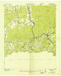 1935 Hartford1935 Print · USGSCocke County’s river valleys and mountain peaks are captured here in the mid-1930s as the national park took shape. Researchers can trace the river-economy through HARTFORD and Naillon Sta or locate family sites like Padgett Mill and Catons Grove.
End of results
Showing maps 1-2 of 2
Top cities near Cosby
- Newport historical maps
- Gatlinburg historical maps
- Dandridge historical maps
- Pittman Center historical maps
- Baneberry historical maps
- Parrottsville historical maps
Frequently asked questions
- What are the different types of historical maps available for Cosby?
- What is the oldest map of Cosby?
- Where can I purchase historical maps of Cosby for my home or office?
- Where can I download high-res historical maps of Cosby?
- Are there historical topographic maps available for Cosby?
- Is there historical aerial imagery available for Cosby?
- Where are historical maps of Cosby sourced from?