1950s Maps of Mudtavern, Nashville
Explore 4 historic maps of Mudtavern from the 1950s. These maps offer a rare glimpse into what life looked like during the 1950s — showing old roads, neighborhoods, homes, and landmarks that have changed or disappeared over time.
Whether you're researching your family's past, planning a metal detecting trip, or studying how Mudtavern's landscape evolved across the 1950s, these high-resolution maps are a powerful tool for exploring the history of this region.
- Focus on a specific era: All maps on this page are from the 1950s, giving you a focused view of this time period.
- See what’s changed: Compare century-old streets, trails, and buildings to today's modern landscape using overlays and satellite layers.
- Research with precision: Use these maps for genealogy, historical research, land use analysis, or educational projects.
- View, download, or print: Maps are fully viewable online in high resolution, and can be downloaded or printed for your own records.
Start exploring Mudtavern's history through authentic maps from the 1950s. This is your window into the past.
Mudtavern, Nashville maps
(4)- 1952 Map of Nashville East, 1954 Print
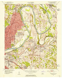 1952 Nashville East1954 Print · USGSEast Nashville and the Cumberland River are captured in the early fifties as post-war growth reaches Donelson and Inglewood. Trace family history at Mount Olivet Cemetery or locate old landmarks like the State School for the Blind and the Phosphate Mine.
 - 1956 Map of Nashville, 1971 Print
 1956 Nashville1971 Print · USGSThe Tennessee-Kentucky borderlands come into focus in the mid-1960s as major reservoir projects transformed the Cumberland and Tennessee river valleys. Researchers can trace the rail networks of the Louisville and Nashville and visit sites like Fort Campbell and Fort Donelson National Military Park.2 unique versions available
 - 1957 Map of Nashville East, 1959 Print
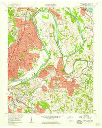 1957 Nashville East1959 Print · USGSEast Nashville and the surrounding river bends are captured here in the late fifties as suburban growth began to surround historic riverside institutions. Researchers can trace the development of Donelson, locate family plots in Mount Olivet Cemetery, or study the early layout of Berry Field.2 unique versions available
 - 1959 Map of Nashville
 1959 Nashville1959 Print · USGSMiddle Tennessee and Southern Kentucky come into focus during the late fifties, showing the region's transition into a modern transportation and military hub. Researchers can trace the sprawling Fort Campbell Military Reservation or locate historic rail stops along the Tennessee Central Ry and Illinois Central RR.
End of results
Showing maps 1-4 of 4
Frequently asked questions
- What are the different types of historical maps available for Mudtavern?
- What is the oldest map of Mudtavern?
- Where can I purchase historical maps of Mudtavern for my home or office?
- Where can I download high-res historical maps of Mudtavern?
- Are there historical topographic maps available for Mudtavern?
- Is there historical aerial imagery available for Mudtavern?
- Where are historical maps of Mudtavern sourced from?