1900s (20th Century) Maps of Jeannette, Tennessee
Explore 5 historic maps of Jeannette from the 1900s (20th Century). These maps offer a rare glimpse into what life looked like during the 1900s — showing old roads, neighborhoods, homes, and landmarks that have changed or disappeared over time.
Whether you're researching your family's past, planning a metal detecting trip, or studying how Jeannette's landscape evolved across the 1900s, these high-resolution maps are a powerful tool for exploring the history of this region.
- Focus on a specific era: All maps on this page are from the 1900s, giving you a focused view of this time period.
- See what’s changed: Compare century-old streets, trails, and buildings to today's modern landscape using overlays and satellite layers.
- Research with precision: Use these maps for genealogy, historical research, land use analysis, or educational projects.
- View, download, or print: Maps are fully viewable online in high resolution, and can be downloaded or printed for your own records.
Start exploring Jeannette's history through authentic maps from the 1900s. This is your window into the past.
Jeannette, TN maps
(5)- 1936 Map of Jeannette
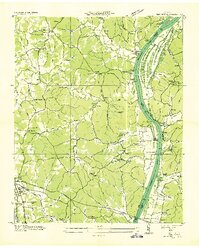 1936 Jeannette1936 Print · USGSDecatur County's riverbank communities and hills are captured here in the mid-thirties as the Tennessee River valley underwent significant change. Genealogists and historians can locate family landmarks like Walker Cem and trace the paths to Busseltown or Bells Store.
 - 1949 Map of Jeannette, 1953 Print
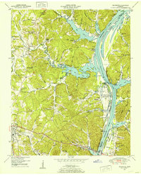 1949 Jeannette1953 Print · USGSDecatur County's riverfront landscape is shown here in the late 1940s as the Tennessee River valley adjusted to the presence of Kentucky Lake. Genealogists and historians can trace family locations through Rocky Hill School, Salem Ch, and the Dismantled RR near Parsons.2 unique versions available
 - 1956 Map of Blytheville, 1964 Print
 1956 Blytheville1964 Print · USGSWest Tennessee and the Arkansas Delta come alive in this mid-century survey of the river-and-rail corridor connecting Memphis to Jackson. Genealogists and historians can trace the rail lines of the Louisville and Nashville RR and locate landmarks like Western State Hospital or Fort Pillow State Prison Farm.2 unique versions available
 - 1959 Map of Blytheville
 1959 Blytheville1959 Print · USGSWest Tennessee and Northeast Arkansas meet along the river in the late fifties, during a period of steady industrial and agricultural growth. Genealogists can trace the rail corridors of the Illinois Central through Jackson or explore landmarks like Shiloh National Military Park and Fort Pillow State Prison.
 - 1986 Map of Milan
 1986 Milan1986 Print · USGSWest Tennessee in the mid-eighties shows a landscape defined by industrial military sites and expansive state forests. Trace the rail lines of the Seaboard System RR, locate the Milan Arsenal, or explore the protected lands of Natchez Trace State Forest.2 unique versions available
End of results
Showing maps 1-5 of 5
Top cities near Jeannette
Frequently asked questions
- What are the different types of historical maps available for Jeannette?
- What is the oldest map of Jeannette?
- Where can I purchase historical maps of Jeannette for my home or office?
- Where can I download high-res historical maps of Jeannette?
- Are there historical topographic maps available for Jeannette?
- Is there historical aerial imagery available for Jeannette?
- Where are historical maps of Jeannette sourced from?