1930s Maps of Mount Pleasant Industrial Park, Greene County
Explore 2 historic maps of Mount Pleasant Industrial Park from the 1930s. These maps offer a rare glimpse into what life looked like during the 1930s — showing old roads, neighborhoods, homes, and landmarks that have changed or disappeared over time.
Whether you're researching your family's past, planning a metal detecting trip, or studying how Mount Pleasant Industrial Park's landscape evolved across the 1930s, these high-resolution maps are a powerful tool for exploring the history of this region.
- Focus on a specific era: All maps on this page are from the 1930s, giving you a focused view of this time period.
- See what’s changed: Compare century-old streets, trails, and buildings to today's modern landscape using overlays and satellite layers.
- Research with precision: Use these maps for genealogy, historical research, land use analysis, or educational projects.
- View, download, or print: Maps are fully viewable online in high resolution, and can be downloaded or printed for your own records.
Start exploring Mount Pleasant Industrial Park's history through authentic maps from the 1930s. This is your window into the past.
Mount Pleasant Industrial Park, Greene County maps
(2)- 1935 Map of Mosheim
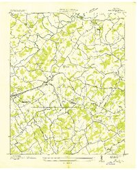 1935 Mosheim1935 Print · USGSMid-1930s Greene County revolves around the rail-and-road corridor of Mosheim. Genealogists can trace rural homesteads near Clarissa Ramsey Memorial Chapel or locate the historic Gilbreath Sch and New Bethel Sch.
 - 1939 Map of Mosheim
 1939 Mosheim1939 Print · USGSGreene County community life thrived in the late thirties along the SOUTHERN railroad and the Andrew Johnson Highway. Researchers can trace rural roots at Hawkins Cem or locate several local landmarks like Hull Mill and Ramsey Chapel.3 unique versions available
End of results
Showing maps 1-2 of 2
Frequently asked questions
- What are the different types of historical maps available for Mount Pleasant Industrial Park?
- What is the oldest map of Mount Pleasant Industrial Park?
- Where can I purchase historical maps of Mount Pleasant Industrial Park for my home or office?
- Where can I download high-res historical maps of Mount Pleasant Industrial Park?
- Are there historical topographic maps available for Mount Pleasant Industrial Park?
- Is there historical aerial imagery available for Mount Pleasant Industrial Park?
- Where are historical maps of Mount Pleasant Industrial Park sourced from?