1940s Maps of The Farm at Hampton Meadows, Hamilton County
Explore 2 historic maps of The Farm at Hampton Meadows from the 1940s. These maps offer a rare glimpse into what life looked like during the 1940s — showing old roads, neighborhoods, homes, and landmarks that have changed or disappeared over time.
Whether you're researching your family's past, planning a metal detecting trip, or studying how The Farm at Hampton Meadows's landscape evolved across the 1940s, these high-resolution maps are a powerful tool for exploring the history of this region.
- Focus on a specific era: All maps on this page are from the 1940s, giving you a focused view of this time period.
- See what’s changed: Compare century-old streets, trails, and buildings to today's modern landscape using overlays and satellite layers.
- Research with precision: Use these maps for genealogy, historical research, land use analysis, or educational projects.
- View, download, or print: Maps are fully viewable online in high resolution, and can be downloaded or printed for your own records.
Start exploring The Farm at Hampton Meadows's history through authentic maps from the 1940s. This is your window into the past.
The Farm at Hampton Meadows, Hamilton County maps
(2)- 1942 Map of Snow Hill, 1954 Print
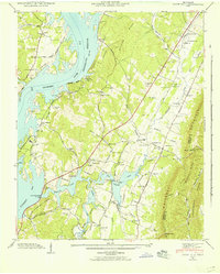 1942 Snow Hill1954 Print · USGSHamilton County communities adapt to a changing riverfront in the early 1940s as the Chickamauga Reservoir fills the valley. Researchers can trace dozens of family landmarks like Scoggins Mill, Anderson Cem, and Savannah Ch.
 - 1943 Map of Snow Hill
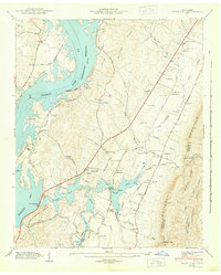 1943 Snow Hill1943 Print · USGSSnow Hill and the eastern banks of the Tennessee River are shown here in the early 1940s as the new reservoir transformed the landscape. Researchers can trace family history through dozens of landmarks, including Scoggins Mill, Snow Hill, and the Penny Cem.2 unique versions available
End of results
Showing maps 1-2 of 2
Frequently asked questions
- What are the different types of historical maps available for The Farm at Hampton Meadows?
- What is the oldest map of The Farm at Hampton Meadows?
- Where can I purchase historical maps of The Farm at Hampton Meadows for my home or office?
- Where can I download high-res historical maps of The Farm at Hampton Meadows?
- Are there historical topographic maps available for The Farm at Hampton Meadows?
- Is there historical aerial imagery available for The Farm at Hampton Meadows?
- Where are historical maps of The Farm at Hampton Meadows sourced from?