1900s (20th Century) Maps of Saltillo, Tennessee
Explore 7 historic maps of Saltillo from the 1900s (20th Century). These maps offer a rare glimpse into what life looked like during the 1900s — showing old roads, neighborhoods, homes, and landmarks that have changed or disappeared over time.
Whether you're researching your family's past, planning a metal detecting trip, or studying how Saltillo's landscape evolved across the 1900s, these high-resolution maps are a powerful tool for exploring the history of this region.
- Focus on a specific era: All maps on this page are from the 1900s, giving you a focused view of this time period.
- See what’s changed: Compare century-old streets, trails, and buildings to today's modern landscape using overlays and satellite layers.
- Research with precision: Use these maps for genealogy, historical research, land use analysis, or educational projects.
- View, download, or print: Maps are fully viewable online in high resolution, and can be downloaded or printed for your own records.
Start exploring Saltillo's history through authentic maps from the 1900s. This is your window into the past.
Saltillo, TN maps
(7)- 1936 Map of Hookers Bend
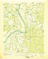 1936 Hookers Bend1936 Print · USGSHardin County river life is captured here in the mid-1930s, showing the early infrastructure of the Tennessee Valley Authority along the river. Researchers can trace rural family roots through landmarks like Saltillo Ferry, Goshen Cem, and Antioch Sch.
 - 1936 Map of Thurman
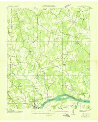 1936 Thurman1936 Print · USGSThe Tennessee River valley at Pitts Bend is captured here in the mid-thirties, showing a landscape of riverfront landings and upland farms. Genealogists can trace family names at Altillo Cem and Bethel Cem or find old school sites like Doe Creek Sch.
 - 1949 Map of Hookers Bend, 1952 Print
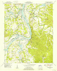 1949 Hookers Bend1952 Print · USGSHardin County during the late 1940s reveals a river-centered society adapting to the creation of Kentucky Lake. Genealogists and historians can trace family locations through sites like Cerro Gordo, the Anderson Cem, and old river stops at Cravens Landing.2 unique versions available
 - 1949 Map of Thurman, 1952 Print
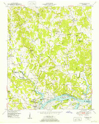 1949 Thurman1952 Print · USGSThe Tennessee River shoreline at the turn of the 1950s is captured here in detail, showing the river-based economy of Decatur County. Researchers can trace old family names and settlements like Lick Skillet, find the Union Hall School, or locate river landings at Swallow Bluff.2 unique versions available
 - 1956 Map of Blytheville, 1964 Print
 1956 Blytheville1964 Print · USGSWest Tennessee and the Arkansas Delta come alive in this mid-century survey of the river-and-rail corridor connecting Memphis to Jackson. Genealogists and historians can trace the rail lines of the Louisville and Nashville RR and locate landmarks like Western State Hospital or Fort Pillow State Prison Farm.2 unique versions available
 - 1959 Map of Blytheville
 1959 Blytheville1959 Print · USGSWest Tennessee and Northeast Arkansas meet along the river in the late fifties, during a period of steady industrial and agricultural growth. Genealogists can trace the rail corridors of the Illinois Central through Jackson or explore landmarks like Shiloh National Military Park and Fort Pillow State Prison.
 - 1986 Map of Selmer
 1986 Selmer1986 Print · USGSThe Tennessee River valley and the West Tennessee highlands come into focus in the mid-eighties, showing the region's unique intersection of Civil War history and modern infrastructure. Genealogists and researchers can trace family landmarks like Gillisses Mills, the campus of Freed-Hardeman College, and the hallowed grounds of Shiloh National Military Park.3 unique versions available
End of results
Showing maps 1-7 of 7
Top cities near Saltillo
- Savannah historical maps
- Clifton historical maps
- Adamsville historical maps
- Crump historical maps
- Decaturville historical maps
- Sardis historical maps
See more
Frequently asked questions
- What are the different types of historical maps available for Saltillo?
- What is the oldest map of Saltillo?
- Where can I purchase historical maps of Saltillo for my home or office?
- Where can I download high-res historical maps of Saltillo?
- Are there historical topographic maps available for Saltillo?
- Is there historical aerial imagery available for Saltillo?
- Where are historical maps of Saltillo sourced from?