1930s Maps of Rogersville, Tennessee
Explore 5 historic maps of Rogersville from the 1930s. These maps offer a rare glimpse into what life looked like during the 1930s — showing old roads, neighborhoods, homes, and landmarks that have changed or disappeared over time.
Whether you're researching your family's past, planning a metal detecting trip, or studying how Rogersville's landscape evolved across the 1930s, these high-resolution maps are a powerful tool for exploring the history of this region.
- Focus on a specific era: All maps on this page are from the 1930s, giving you a focused view of this time period.
- See what’s changed: Compare century-old streets, trails, and buildings to today's modern landscape using overlays and satellite layers.
- Research with precision: Use these maps for genealogy, historical research, land use analysis, or educational projects.
- View, download, or print: Maps are fully viewable online in high resolution, and can be downloaded or printed for your own records.
Start exploring Rogersville's history through authentic maps from the 1930s. This is your window into the past.
Rogersville, TN maps
(5)- 1935 Map of Surgoinsville
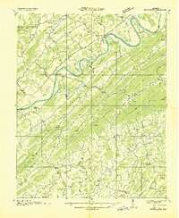 1935 Surgoinsville1935 Print · USGSHawkins and Greene counties are shown in the mid-1930s as the Tennessee Valley Authority began documenting the Holston River corridor. Genealogists can trace early homesteads and landmarks like Hennard Mill, Alumwell Academy, and Beech Creek Cem among the numerous mountain hollows.
 - 1935 Map of Rogersville
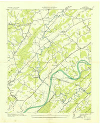
 1935 Rogersville1935 Print · USGSHawkins and Greene Counties come alive in the mid-1930s, showing a landscape of ridge-top schools and river-bottom farms. Genealogists can trace family footprints near Pressmans Home, Bulls Gap, and local centers like Macedonia Ch.
 - 1935 Map of Burem
 1935 Burem1935 Print · USGSHawkins County is captured here in the mid-1930s, showing a river-valley landscape shaped by the Holston River and Southern Railway. Genealogists can trace family roots through numerous local landmarks like Alumwell Academy, Hennard Mill, and Yellow Store.
 - 1935 Map of Pressmens Home
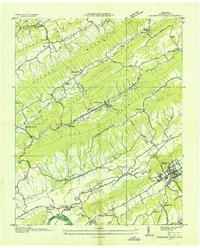 1935 Pressmens Home1935 Print · USGSHawkins County is seen here during the mid-1930s as the TVA began modernizing the valley floor below Clinch Mountain. Genealogists and historians can locate old rural landmarks like Maddox Ford, the Stone Mountain School, and the unique institutional complex at Pressmens Home.
 - 1939 Map of Burem, 1954 Print
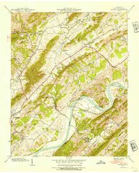 1939 Burem1954 Print · USGSHawkins County is captured here in the late thirties, a landscape of ridge-and-valley farming anchored by the Holston River. Genealogists can trace family lines through numerous rural landmarks like Alumwell Academy, the Miller Cem, and the unique Ebbing and Flowing Spring.2 unique versions available
End of results
Showing maps 1-5 of 5
Top cities near Rogersville
- Morristown historical maps
- Greeneville historical maps
- Church Hill historical maps
- Tusculum historical maps
- Mosheim historical maps
- Surgoinsville historical maps
See more
Top neighborhoods of Rogersville
Frequently asked questions
- What are the different types of historical maps available for Rogersville?
- What is the oldest map of Rogersville?
- Where can I purchase historical maps of Rogersville for my home or office?
- Where can I download high-res historical maps of Rogersville?
- Are there historical topographic maps available for Rogersville?
- Is there historical aerial imagery available for Rogersville?
- Where are historical maps of Rogersville sourced from?