1930s Maps of India, Tennessee
Explore 1 historic maps of India from the 1930s. These maps offer a rare glimpse into what life looked like during the 1930s — showing old roads, neighborhoods, homes, and landmarks that have changed or disappeared over time.
Whether you're researching your family's past, planning a metal detecting trip, or studying how India's landscape evolved across the 1930s, these high-resolution maps are a powerful tool for exploring the history of this region.
- Focus on a specific era: All maps on this page are from the 1930s, giving you a focused view of this time period.
- See what’s changed: Compare century-old streets, trails, and buildings to today's modern landscape using overlays and satellite layers.
- Research with precision: Use these maps for genealogy, historical research, land use analysis, or educational projects.
- View, download, or print: Maps are fully viewable online in high resolution, and can be downloaded or printed for your own records.
Start exploring India's history through authentic maps from the 1930s. This is your window into the past.
India, TN maps
(1)- 1936 Map of Paris
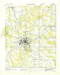 1936 Paris1936 Print · USGSHenry County is captured here in the mid-1930s as a bustling railroad hub and a focus of New Deal-era development. Genealogists and historians can trace family locations near Paris, CCC Camp TVA No 36, and numerous rural landmarks like Vandyke Grove Ch and Maplewood Cem.
End of results
Showing maps 1-1 of 1
Top cities near India
- Paris historical maps
- McKenzie historical maps
- Camden historical maps
- Puryear historical maps
- Henry historical maps
- Big Sandy historical maps
See more
Frequently asked questions
- What are the different types of historical maps available for India?
- What is the oldest map of India?
- Where can I purchase historical maps of India for my home or office?
- Where can I download high-res historical maps of India?
- Are there historical topographic maps available for India?
- Is there historical aerial imagery available for India?
- Where are historical maps of India sourced from?