1930s Maps of Douglas Estates, Jefferson County
Explore 3 historic maps of Douglas Estates from the 1930s. These maps offer a rare glimpse into what life looked like during the 1930s — showing old roads, neighborhoods, homes, and landmarks that have changed or disappeared over time.
Whether you're researching your family's past, planning a metal detecting trip, or studying how Douglas Estates's landscape evolved across the 1930s, these high-resolution maps are a powerful tool for exploring the history of this region.
- Focus on a specific era: All maps on this page are from the 1930s, giving you a focused view of this time period.
- See what’s changed: Compare century-old streets, trails, and buildings to today's modern landscape using overlays and satellite layers.
- Research with precision: Use these maps for genealogy, historical research, land use analysis, or educational projects.
- View, download, or print: Maps are fully viewable online in high resolution, and can be downloaded or printed for your own records.
Start exploring Douglas Estates's history through authentic maps from the 1930s. This is your window into the past.
Douglas Estates, Jefferson County maps
(3)- 1935 Map of English Mountain
 1935 English Mountain1935 Print · USGSSevier County and the foothills of the Smokies are seen here during the mid-thirties as the national park was taking shape. Genealogists can trace family roots through scores of rural institutions like Smoky Mtn Academy, Pittman Center, and the Crockettville Sch.
 - 1935 Map of Clevenger
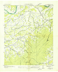 1935 Clevenger1935 Print · USGSJefferson and Cocke Counties are shown in the mid-1930s, featuring the rural communities nestled against the slopes of English Mountain. Genealogists and historians can locate family landmarks like Bridges Ch, trace the site of CCC Camp No 1467, or find the old Blowing Cave Mill.
 - 1939 Map of Clevenger, 1954 Print
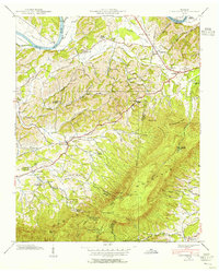 1939 Clevenger1954 Print · USGSJefferson and Cocke counties meet along the French Broad River in the late thirties, just as the local highway network was expanding. Genealogists can trace early homesteads and landmarks like Blowing Cave Mill, Bird Crossroads, and the Bogard Ch Rainwater Sch.
End of results
Showing maps 1-3 of 3
Frequently asked questions
- What are the different types of historical maps available for Douglas Estates?
- What is the oldest map of Douglas Estates?
- Where can I purchase historical maps of Douglas Estates for my home or office?
- Where can I download high-res historical maps of Douglas Estates?
- Are there historical topographic maps available for Douglas Estates?
- Is there historical aerial imagery available for Douglas Estates?
- Where are historical maps of Douglas Estates sourced from?