1930s Maps of Neva, Tennessee
Explore 3 historic maps of Neva from the 1930s. These maps offer a rare glimpse into what life looked like during the 1930s — showing old roads, neighborhoods, homes, and landmarks that have changed or disappeared over time.
Whether you're researching your family's past, planning a metal detecting trip, or studying how Neva's landscape evolved across the 1930s, these high-resolution maps are a powerful tool for exploring the history of this region.
- Focus on a specific era: All maps on this page are from the 1930s, giving you a focused view of this time period.
- See what’s changed: Compare century-old streets, trails, and buildings to today's modern landscape using overlays and satellite layers.
- Research with precision: Use these maps for genealogy, historical research, land use analysis, or educational projects.
- View, download, or print: Maps are fully viewable online in high resolution, and can be downloaded or printed for your own records.
Start exploring Neva's history through authentic maps from the 1930s. This is your window into the past.
Neva, TN maps
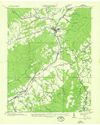
(3)- 1935 Map of Doe Mountain
 1935 Doe Mountain1935 Print · USGSMountain City and the Watauga River valley appear here in the mid-1930s, just before major hydroelectric projects transformed the landscape. Researchers can trace the original river towns of Butler and Elk Mills, or locate family landmarks like Shouns Chapel Sch and Doeville P O Doe Sta.2 unique versions available
 - 1935 Map of Mountain City
 1935 Mountain City1935 Print · USGSUpper East Tennessee's mountain valleys are captured here in the mid-1930s, centered on the bustling county seat and its surrounding rail-fed hamlets. Genealogists can trace family names through landmarks like Vaughtsville P O, Crackers Neck, and Shouns Chapel Sch.
 - 1938 Map of Mountain City
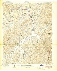 1938 Mountain City1938 Print · USGSJohnson County in the late thirties is a landscape of mountain hollows and rail-connected settlements. Genealogists and researchers can trace family roots through numerous local landmarks like Vaughtsville PO, Crackers Neck, and Kettlefoot Lookout Tower.7 unique versions available
End of results
Showing maps 1-3 of 3
Top cities near Neva
Frequently asked questions
- What are the different types of historical maps available for Neva?
- What is the oldest map of Neva?
- Where can I purchase historical maps of Neva for my home or office?
- Where can I download high-res historical maps of Neva?
- Are there historical topographic maps available for Neva?
- Is there historical aerial imagery available for Neva?
- Where are historical maps of Neva sourced from?