1900s (20th Century) Maps of Quail Run Meadows, Maury County
Explore 5 historic maps of Quail Run Meadows from the 1900s (20th Century). These maps offer a rare glimpse into what life looked like during the 1900s — showing old roads, neighborhoods, homes, and landmarks that have changed or disappeared over time.
Whether you're researching your family's past, planning a metal detecting trip, or studying how Quail Run Meadows's landscape evolved across the 1900s, these high-resolution maps are a powerful tool for exploring the history of this region.
- Focus on a specific era: All maps on this page are from the 1900s, giving you a focused view of this time period.
- See what’s changed: Compare century-old streets, trails, and buildings to today's modern landscape using overlays and satellite layers.
- Research with precision: Use these maps for genealogy, historical research, land use analysis, or educational projects.
- View, download, or print: Maps are fully viewable online in high resolution, and can be downloaded or printed for your own records.
Start exploring Quail Run Meadows's history through authentic maps from the 1900s. This is your window into the past.
Quail Run Meadows, Maury County maps
(5)- 1936 Map of Carters Creek
 1936 Carters Creek1936 Print · USGSThe northern reaches of Maury County are captured in the mid-1930s as the rural economy centered around the Rutherford Creek basin. Genealogists can locate family landmarks like Buford Cem, Smith Chapel, and the historic Greens Mill.
 - 1941 Map of Carters Creek
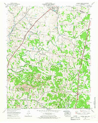
 1941 Carters Creek1941 Print · USGSCentral Tennessee at the start of the 1940s reveals a landscape of rural schoolhouses and family cemeteries along the Andrew Jackson Highway. Trace early mineral industry at the Phosphate Mine or locate ancestral sites like Old Brick Ch and Buford Cem.2 unique versions available
 - 1956 Map of Columbia, 1960 Print
 1956 Columbia1960 Print · USGSMiddle Tennessee in the mid-fifties presents a landscape of established river towns and critical rail hubs before the arrival of the modern interstate system. Researchers can trace the routes of the Louisville and Nashville railroad or locate historic landmarks like Stones River National Military Park and the Tennessee National Wildlife Refuge.6 unique versions available
 - 1965 Map of Carters Creek, 1967 Print
 1965 Carters Creek1967 Print · USGSMaury and Williamson Counties are shown here during the mid-1960s, a period defined by established agricultural research and active mining operations. Researchers can trace family history at Meadow Lawn Memorial Garden or locate the Tennessee Orphans Home and Lanton Church.2 unique versions available
 - 1985 Map of Murfreesboro, 1986 Print
 1985 Murfreesboro1986 Print · USGSMiddle Tennessee in the mid-1980s shows a landscape of growing towns and deep-rooted rural outposts. Local researchers can trace old family lines near Bell Buckle, locate landmarks like Donnel Chapel, or explore the grounds of Henry Horton State Park and Hoovers Gap.
End of results
Showing maps 1-5 of 5
Frequently asked questions
- What are the different types of historical maps available for Quail Run Meadows?
- What is the oldest map of Quail Run Meadows?
- Where can I purchase historical maps of Quail Run Meadows for my home or office?
- Where can I download high-res historical maps of Quail Run Meadows?
- Are there historical topographic maps available for Quail Run Meadows?
- Is there historical aerial imagery available for Quail Run Meadows?
- Where are historical maps of Quail Run Meadows sourced from?