Old Maps of Sullivan County, Tennessee for Genealogy
Trace your family roots with 159 historic maps of Sullivan County. These high-res maps reveal old neighborhoods, homesites, landmarks, and streets — helping you uncover where your ancestors lived and how the area evolved over time.
- Explore historic neighborhoods: Identify where your relatives may have lived in the 1800s or 1900s.
- Compare maps over time: Trace the changes in streets, buildings, and landmarks for multi-generational research.
- Perfect for genealogy & ancestry research: Used by family historians and researchers to map out lineage and migration.
These maps are an incredible resource for exploring your personal connection to Sullivan County's past.
Sullivan County, TN maps
(159)- 1891 Map of Roan Mountain
 1891 Roan Mountain1891 Print · USGSThe Tennessee-North Carolina border country comes alive in the 1890s, when narrow-gauge railroads and mountain ferries still moved the region's goods. Genealogists and historians can trace early crossings like Shipley's Ferry, industrial sites at Embreeville, and high-country settlements like Cloudland.
 - 1891 Map of Abingdon
 1891 Abingdon1891 Print · USGSSouthwest Virginia in the 1890s reveals a landscape of mountain ridges and thriving valley settlements along the Norfolk and Western R. R. Lineages can be traced through sites like Emory and Henry College, Saltville, and numerous family-named landmarks like Vance's Mill.
 - 1892 Map of Greeneville
 1892 Greeneville1892 Print · USGSEast Tennessee in the late nineteenth century was a landscape of river-crossing ferries and mountain gaps centered on Greeneville. Genealogists and historians can trace the early rail corridor of the East Tennessee Virginia and Georgia R. R. and locate family-named sites like Britton Ferry and Evans X Rds.
 - 1893 Map of Cranberry
 1893 Cranberry1893 Print · USGSThe high country of the Blue Ridge and Appalachians is captured here during the late 1800s, showing the early settlements and crossroads of Watauga and Johnson counties. Genealogists can trace family landmarks and early industry at Rhea Forge, Shulls Mill, and the many hamlets like Vilas and Sutherland.
 - 1894 Map of Roan Mountain
 1894 Roan Mountain1894 Print · USGSNortheast Tennessee and Western North Carolina are mapped here in the late nineteenth century as the rail network expands through the Unaka Range. Trace early industrial footprints and family lands near Elizabethton, Terry Furnace, and the high summit at Cloudland.3 unique versions available
 - 1894 Map of Abingdon, 1896 Print
 1894 Abingdon1896 Print · USGSSouthwest Virginia's valley and ridge country is captured here during the peak of the rail era, centered on the Abingdon and Marion corridors. Local historians can trace the foundations of Emory and Henry College and numerous rural mill sites like Belfast Mills or Vance's Mill.5 unique versions available
 - 1894 Map of Estillville, 1909 Print
 1894 Estillville1909 Print · USGSThe Appalachian highlands at the turn of the century show a landscape of isolated mountain hollows and emerging rail hubs. Genealogists can trace family footprints across river crossings like Speer Ferry and vanished industry at Zion Mills or Brick Store.3 unique versions available
 - 1895 Map of Cranberry
 1895 Cranberry1895 Print · USGSThe High Country of North Carolina and Tennessee comes alive in this late nineteenth-century survey. Genealogists and historians can trace the foundations of Mountain City or locate old community centers like Valle Cruces, Banners Elk, and Rhea Forge.
 - 1896 Map of Greeneville
 1896 Greeneville1896 Print · USGSUpper East Tennessee thrives in the late nineteenth century as a hub of rail travel and river commerce centered around the county seat. Genealogists can trace family roots through numerous crossroads and post offices like Chissolms P. O., Hawes X Roads, and Britton Ferry.2 unique versions available
 - 1897 Map of Bristol
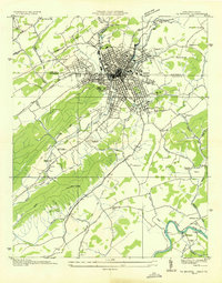
 1897 Bristol1897 Print · USGSThe Tennessee-Virginia borderlands in the late nineteenth century were a landscape of steep ridges and river-dependent commerce. Genealogists can trace family homesteads near Bickley Mill, locate river crossings like Childress Ferry, or find early rail stops along the Norfolk and Western RR.
 - 1899 Map of Cranberry
 1899 Cranberry1899 Print · USGSThe high Appalachian borderlands of North Carolina and Tennessee appear here in the late nineteenth century, defined by mountain settlements and early river-powered industry. Researchers can trace the era's geography through landmarks like Rhea Forge, Shills Mill, and the historic Yonhalossee Road.
 - 1902 Map of Bristol
 1902 Bristol1902 Print · USGSThe interstate border region around Bristol appears here at the start of the twentieth century, defined by its deep mountain ridges and river valleys. Researchers can trace the early industrial footprint of the area through numerous landmarks like Bickley Mill, Kings Mill, and the Norfolk and Western RR.6 unique versions available
 - 1902 Map of Cranberry
 1902 Cranberry1902 Print · USGSThe North Carolina and Tennessee borderlands are captured here at the turn of the century as early railroads began penetrating the high ridges. Genealogists can trace family names and old settlements like Mountain City, Shoun Crossroads, and the industry at Rhea Forge.6 unique versions available
 - 1904 Map of Roan Mountain
 1904 Roan Mountain1904 Print · USGSUpper East Tennessee and Western North Carolina are documented here at a time when river fords and narrow-gauge railroads still connected mountain hollows. Trace the paths to Hodge Ore Bank, find old Poplar Ridge Church, or locate river crossings like Yoakley Ferry.4 unique versions available
 - 1904 Map of Greeneville
 1904 Greeneville1904 Print · USGSEast Tennessee at the turn of the century reveals a land of ridge-valley farms and early educational centers. Genealogists can trace family roots through historic settlements like Surgoinsville, early institutions like Washington College, and landmarks such as Bashors Mill.4 unique versions available
 - 1909 Map of Abingdon
 1909 Abingdon1909 Print · USGSSouthwest Virginia at the first decade's end shows a valley landscape defined by the iron rail and steep ridges. Genealogists and historians can trace the early layouts of Abingdon and Glade Spring, or locate landmarks like Dove Mills and the County Farm.2 unique versions available
 - 1911 Map of Abingdon
 1911 Abingdon1911 Print · USGSSouthwest Virginia's rugged corridors are captured here during the height of the mountain rail era. Genealogists and historians can trace old homesteads and local landmarks such as Whites Mill, Valley Church, and the County Farm near Abingdon.5 unique versions available
 - 1934 Map of Holston Valley
 1934 Holston Valley1934 Print · USGSThe Holston Valley was a landscape of river fords and rural outposts in the mid-1930s. Genealogists and historians can trace family ties through Stuffels Cem, locate old mills like Old Kings Mill, and find river crossings at Shady Ford.
 - 1934 Map of Bristol
 1934 Bristol1934 Print · USGSThe border-straddling community of Bristol is shown at a mid-thirties crossroads of rail and road. Local historians can trace the foundations of the area through the Bristol Landing Field, Beidleman Mill, and dozens of rural schools and churches.
 - 1935 Map of Lovelace
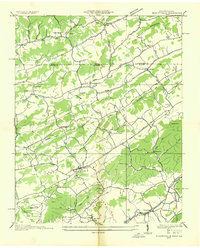
 1935 Lovelace1935 Print · USGSHawkins and Sullivan counties are captured here in the mid-thirties, showing a landscape of ridge-top beacons and creek-side mills. Researchers can trace rural family life through landmarks like Dykes Mill, Mountain View Sch, and the Airway Beacon atop the peaks.
 - 1935 Map of Watauga Valley
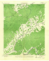
 1935 Watauga Valley1935 Print · USGSUpper East Tennessee's river valleys and mountain ridges are documented here during the mid-thirties, centered on the growing industrial hub of Elizabethton. Researchers can locate numerous vanished landmarks, from the Manganese Mine to rural schoolhouses like Caldwell Springs Sch.
 - 1935 Map of Sullivan Gardens
 1935 Sullivan Gardens1935 Print · USGSSullivan County in the mid-1930s shows a landscape of ridge-top schools and creek-side mills before the expansion of modern highways. Researchers can locate the Kincheloe Mill, trace the Clinchfield RR through Kendricks Tunnel, and find family sites at Harmony Cem.
 - 1935 Map of Moggasin
 1935 Moggasin1935 Print · USGSThe Virginia-Tennessee borderlands appear here in the mid-1930s, showing the early industrial growth of Kingsport and Gate City. Trace family roots at Wolfe Cem or locate old mills like Speers Ferry Mill along the Clinch River.
 - 1935 Map of Doe
 1935 Doe1935 Print · USGSThe Tennessee mountains at the height of the New Deal era reveal a network of high-country hollows and valley settlements. Genealogists can trace the rural communities of Doeville, Pandora, and Doe Valley alongside landmarks like Campbell Cem.
 - 1935 Map of Blountville
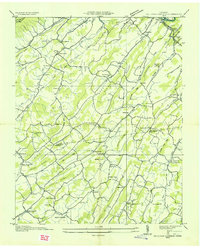
 1935 Blountville1935 Print · USGSSullivan County and the Virginia borderlands are documented here in the mid-1930s, showing a rural landscape organized around the county seat and mountain ridges. Genealogists can trace family locations near Hickory Grove Sch, Linville Cave, and the Sullivan County Farm.2 unique versions available
Showing maps 1-25 of 159
Top cities of Sullivan County
- Kingsport historical maps
- Bristol historical maps
- Bloomingdale historical maps
- Blountville historical maps
- Walnut Hill historical maps
- Bluff City historical maps
Frequently asked questions
- What are the different types of historical maps available for Sullivan County?
- What is the oldest map of Sullivan County?
- Where can I purchase historical maps of Sullivan County for my home or office?
- Where can I download high-res historical maps of Sullivan County?
- Are there historical topographic maps available for Sullivan County?
- Is there historical aerial imagery available for Sullivan County?
- Where are historical maps of Sullivan County sourced from?