1960s Maps of Portage, Utah
Explore 4 historic maps of Portage from the 1960s. These maps offer a rare glimpse into what life looked like during the 1960s — showing old roads, neighborhoods, homes, and landmarks that have changed or disappeared over time.
Whether you're researching your family's past, planning a metal detecting trip, or studying how Portage's landscape evolved across the 1960s, these high-resolution maps are a powerful tool for exploring the history of this region.
- Focus on a specific era: All maps on this page are from the 1960s, giving you a focused view of this time period.
- See what’s changed: Compare century-old streets, trails, and buildings to today's modern landscape using overlays and satellite layers.
- Research with precision: Use these maps for genealogy, historical research, land use analysis, or educational projects.
- View, download, or print: Maps are fully viewable online in high resolution, and can be downloaded or printed for your own records.
Start exploring Portage's history through authentic maps from the 1960s. This is your window into the past.
Portage, UT maps
(4)- 1962 Map of Brigham City
 1962 Brigham City1962 Print · USGSNorthern Utah in the early sixties reveals a landscape of vast salt flats and growing towns along the Wasatch Front. Researchers can trace the Southern Pacific line past the Golden Spike Monument or locate landmarks like Indian Cave and Donner-Reed Pass.
 - 1964 Map of Portage, 1966 Print
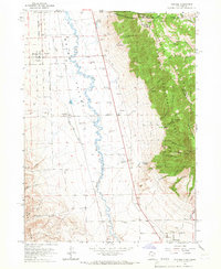 1964 Portage1966 Print · USGSThe Idaho-Utah borderlands are captured here in the mid-1960s, showing the agricultural valley floor set against the peaks of the Cache National Forest. Local researchers can trace family sites in Portage and Washakie, or locate the Washakie Cem and Plymouth Cem.2 unique versions available
 - 1968 Map of Henderson Creek, 1971 Print
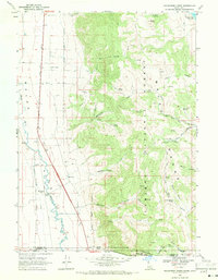 1968 Henderson Creek1971 Print · USGSThe Idaho-Utah borderlands come alive in this late sixties survey of the Malad River valley and its mountain backdrop. Genealogists and hikers can trace the historic Hanson State Boundary Survey or locate the remote Dry Creek Campground and Woodruff siding.2 unique versions available
 - 1968 Map of Limekiln Knoll, 1972 Print
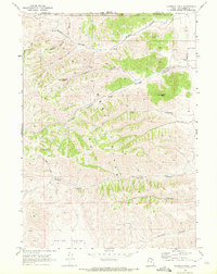 1968 Limekiln Knoll1972 Print · USGSBox Elder County at the Idaho border in the late sixties is a landscape of high ridges and deep drainages. Local researchers can trace old routes via several jeep trails and locate the historic Portage Cemetery near Lemon Peak.
End of results
Showing maps 1-4 of 4
Top cities near Portage
- Malad City historical maps
- Malad historical maps
- Clarkston historical maps
- Fielding historical maps
- Plymouth historical maps
- Clifton historical maps
See more
Frequently asked questions
- What are the different types of historical maps available for Portage?
- What is the oldest map of Portage?
- Where can I purchase historical maps of Portage for my home or office?
- Where can I download high-res historical maps of Portage?
- Are there historical topographic maps available for Portage?
- Is there historical aerial imagery available for Portage?
- Where are historical maps of Portage sourced from?