Old Maps of Kabis and Myers, Salt Lake City for Hiking & Exploration
Hike through history with 11 historic maps of Kabis and Myers. Explore old trails, ghost towns, and forgotten backroads — perfect for outdoor adventurers and local explorers.
- Rediscover forgotten places: Map out old mining camps, roads, and footpaths that no longer exist on modern maps.
- Layer with modern tools: Combine with LiDAR or satellite views to plan hikes through historical terrain.
- Made for exploration: Popular among hikers, overlanders, and local history lovers.
Use these maps to find adventure and explore the hidden past of Kabis and Myers.
Kabis and Myers, Salt Lake City maps
(11)- 1885 Map of Salt Lake
 1885 Salt Lake1885 Print · USGSThe Wasatch Front and surrounding high valleys appear here in the mid-1880s during a period of rapid mining and rail expansion. Genealogists and historians can trace early town sites and mining camps including Alta, Silver City, and the military grounds of Fort Douglass.7 unique versions available
 - 1925 Map of Ft. Douglas
 1925 Ft. Douglas1925 Print · USGSThe Wasatch Range in the mid-1920s shows a landscape of mining camps and early mountain tourism. Genealogists and researchers can trace the old paths of the Lincoln Highway and locate vanished stops like Gogorza, Kimballs, and the Pacific Mine.
 - 1928 Map of Ft. Douglas
 1928 Ft. Douglas1928 Print · USGSIn the mid-1920s, the high country east of Salt Lake was a hive of mining and early canyon tourism. Trace old claim sites like the Pacific Mine or visit early retreats such as Pinecrest Inn and the YWCA Camp during the mining era.2 unique versions available
 - 1951 Map of Salt Lake City North, 1953 Print
 1951 Salt Lake City North1953 Print · USGSSalt Lake City and its northern neighbors appear in the early fifties during a period of significant post-war expansion. Researchers can trace the layout of SALT LAKE CITY and find landmarks like the State Capitol, Becks Hot Springs, and Woods Cross.
 - 1954 Map of Salt Lake City, 1964 Print
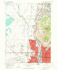
 1954 Salt Lake City1964 Print · USGSThe Wasatch Front and Uinta Mountains are captured here in the mid-fifties, showing the industrial heart of Utah and its high mountain wilderness. Researchers can locate vanished infrastructure and landmarks like the Geneva Steel Plant, Bingham Canyon Mine, and the Utah State Prison.4 unique versions available
 - 1958 Map of Salt Lake City
 1958 Salt Lake City1958 Print · USGSThe Wasatch Front and Uinta Basin are captured during a period of significant post-war growth and industrial development. Researchers can trace the mid-century rail lines of the Bamberger RR and locate sites like the Kiegley Limestone Quarry and Camp Williams Military Reservation.
 - 1960 Map of Salt Lake City
 1960 Salt Lake City1960 Print · USGSThe Wasatch Front and High Uintas are captured mid-century as the Salt Lake Valley underwent significant postwar expansion. Genealogists and historians can trace rail lines like the Union Pacific and locate established landmarks such as Fort Douglas, Camp Williams, and the Bingham Canyon Mine.
 - 1963 Map of Salt Lake City North, 1965 Print
 1963 Salt Lake City North1965 Print · USGSSalt Lake City and its northern neighbors appear in the early sixties during a peak era of aviation and industrial expansion. Genealogists and local historians can trace the development of Rose Park, locate the Pony Express Monument, or find neighborhood schools like Backman Sch.6 unique versions available
 - 1980 Map of Salt Lake City
 1980 Salt Lake City1980 Print · USGSSalt Lake City and the surrounding Wasatch Range are shown in the early eighties during a period of rapid suburban growth. Genealogists and historians can trace old mining operations like the Ontario Mine and Wasatch Mine or follow the path of the Union Pacific through the canyons.3 unique versions available
 - 1998 Map of Salt Lake City North, 2001 Print
 1998 Salt Lake City North2001 Print · USGSSalt Lake City and its northern neighbors appear at the end of the century as the region prepared for the 2002 Winter Olympics. Researchers can trace the massive industrial and transport hubs near Skypark Airport or locate civic landmarks like the State Capitol and the historic Pony Exp Mon.
 - 2023 Map of Salt Lake City North, 2023 Print
 2023 Salt Lake City North2023 Print · USGSThe northern reaches of the Salt Lake Valley are shown here in modern detail, where the urban sprawl meets the steep foothills of the Wasatch Range. Genealogists and historians can trace significant landmarks like the Sessions Settlement-Pioneer Cem and the Cathedral of the Madeleine.
End of results
Showing maps 1-11 of 11
Frequently asked questions
- What are the different types of historical maps available for Kabis and Myers?
- What is the oldest map of Kabis and Myers?
- Where can I purchase historical maps of Kabis and Myers for my home or office?
- Where can I download high-res historical maps of Kabis and Myers?
- Are there historical topographic maps available for Kabis and Myers?
- Is there historical aerial imagery available for Kabis and Myers?
- Where are historical maps of Kabis and Myers sourced from?