1900s (20th Century) Maps of Payson, Utah
Explore 19 historic maps of Payson from the 1900s (20th Century). These maps offer a rare glimpse into what life looked like during the 1900s — showing old roads, neighborhoods, homes, and landmarks that have changed or disappeared over time.
Whether you're researching your family's past, planning a metal detecting trip, or studying how Payson's landscape evolved across the 1900s, these high-resolution maps are a powerful tool for exploring the history of this region.
- Focus on a specific era: All maps on this page are from the 1900s, giving you a focused view of this time period.
- See what’s changed: Compare century-old streets, trails, and buildings to today's modern landscape using overlays and satellite layers.
- Research with precision: Use these maps for genealogy, historical research, land use analysis, or educational projects.
- View, download, or print: Maps are fully viewable online in high resolution, and can be downloaded or printed for your own records.
Start exploring Payson's history through authentic maps from the 1900s. This is your window into the past.
Payson, UT maps
(19)- 1948 Map of Spanish Fork, 1956 Print
 1948 Spanish Fork1956 Print · USGSUtah County at the end of the 1940s shows a thriving network of agricultural towns and mountain mines as the valley modernized. Researchers can trace family roots at Benjamin Cem or locate industrial sites like the Sugar Refinery and the Dream Mine.3 unique versions available
 - 1949 Map of Provo, 1959 Print
 1949 Provo1959 Print · USGSThe Utah Valley thrived in the late post-war years as industrial growth and educational institutions expanded along the eastern shore of Utah Lake. Researchers can locate family roots in settlements like Palmyra and Leland or trace the industrial sites at Ironton and the Sugar Refinery.
 - 1950 Map of Spanish Fork
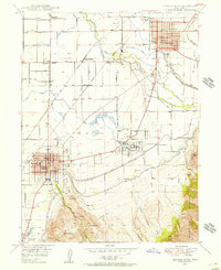
 1950 Spanish Fork1950 Print · USGSThe Utah Valley at mid-century shows a thriving agricultural and industrial corridor shaped by irrigation and rail. Researchers can trace family roots through the Benjamin Cem, locate old schoolhouses like Rees Sch, or find the historic Sugar Refinery.
 - 1950 Map of West Mountain, 1951 Print
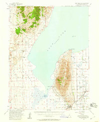
 1950 West Mountain1951 Print · USGSThe foothills of the Wasatch Range meet the shores of Utah Lake in the early 1950s. Genealogists and industrial historians can trace the tracks of the Denver and Rio Grande Western through Goshen Gap to the Keigley Quarry.3 unique versions available
 - 1950 Map of West Mountain, 1959 Print
 1950 West Mountain1959 Print · USGSThe shores of Utah Lake and the industrial corridors of the southern valley come into focus during the mid-century. Genealogists and historians can trace the rail lines of the Union Pacific and locate historic sites like Mosida (Site) and the Keigley Quarry.2 unique versions available
 - 1952 Map of Santaquin Peak, 1954 Print
 1952 Santaquin Peak1954 Print · USGSThe high peaks and forest canyons of central Utah are mapped here in the early fifties, showing the mountain corridor before modern development. Researchers can find old rail routes along Thistle Creek, the Wimmer Ranch homestead, and the remote Payson Guard Station.3 unique versions available
 - 1954 Map of Salt Lake City, 1964 Print
 1954 Salt Lake City1964 Print · USGSThe Wasatch Front and Uinta Mountains are captured here in the mid-fifties, showing the industrial heart of Utah and its high mountain wilderness. Researchers can locate vanished infrastructure and landmarks like the Geneva Steel Plant, Bingham Canyon Mine, and the Utah State Prison.4 unique versions available
 - 1956 Map of Price, 1968 Print
 1956 Price1968 Print · USGSCentral Utah in the mid-fifties showcases a landscape shaped by coal mining and mountain-fed irrigation. Trace the rail-and-river economy through the Geneva Coal Mine, the Union Pacific line, and settlements like Price and Ephraim.3 unique versions available
 - 1958 Map of Salt Lake City
 1958 Salt Lake City1958 Print · USGSThe Wasatch Front and Uinta Basin are captured during a period of significant post-war growth and industrial development. Researchers can trace the mid-century rail lines of the Bamberger RR and locate sites like the Kiegley Limestone Quarry and Camp Williams Military Reservation.
 - 1960 Map of Salt Lake City
 1960 Salt Lake City1960 Print · USGSThe Wasatch Front and High Uintas are captured mid-century as the Salt Lake Valley underwent significant postwar expansion. Genealogists and historians can trace rail lines like the Union Pacific and locate established landmarks such as Fort Douglas, Camp Williams, and the Bingham Canyon Mine.
 - 1960 Map of Price
 1960 Price1960 Print · USGSCentral Utah in the late fifties was a landscape of coal-hauling railroads and high plateau settlements. Genealogists and local historians can trace the rail-to-river economy from Price to the mountain mining camps of Hiawatha, Dragerton, and Sunnyside.2 unique versions available
 - 1962 Map of Price
 1962 Price1962 Print · USGSCentral Utah during the early sixties shows a landscape balancing high-mountain forestry with valley agriculture and coal mining. Genealogists and historians can trace the Denver and Rio Grande Western rail lines through industrial hubs like Price or locate formerly active sites like Coal City (abandoned).
 - 1979 Map of Payson Lakes
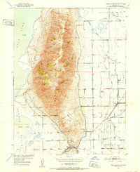
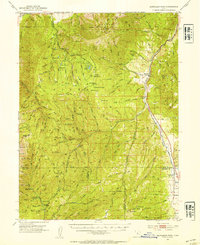
 1979 Payson Lakes1979 Print · USGSHigh mountain ridges south of Provo are captured here in the late seventies as a landscape of mining and recreation. Researchers can trace historic family holdings like Wimmer Ranch alongside the Golden Relief Mine and Payson Lake Guard Sta.
 - 1981 Map of Nephi
 1981 Nephi1981 Print · USGSThe Juab and Sanpete valleys of central Utah are captured here in the early 1980s, during a period of established mountain settlement and rail-based commerce. Researchers can trace the routes of the Union Pacific and visit traditional communities like Nephi, Mount Pleasant, and Scofield.3 unique versions available
 - 1986 Map of Provo
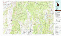
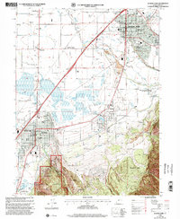
 1986 Provo1986 Print · USGSThe Utah Valley during the mid-eighties shows a bustling corridor of growth between the mountains and Utah Lake. Genealogists and historians can trace the rail lines of the Union Pacific RR through settlements like Springville, Spanish Fork, and Payson.
 - 1994 Map of West Mountain
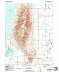 1994 West Mountain1994 Print · USGSThe foothills of Utah County were a hub of heavy industry and irrigation at the start of the nineties. Genealogists and historians can trace the Union Pacific rail lines near Payson Sta or the massive industrial footprint of the Keigley Quarry.
 - 1994 Map of Spanish Fork
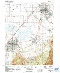 1994 Spanish Fork1994 Print · USGSUtah Valley in the mid-nineties shows a landscape where irrigation canals meet expanding foothill towns. Researchers can trace historic family plots at Benjamin Cem, find the old Sugar Refinery, and locate civic centers in Payson or Salem.
 - 1998 Map of Spanish Fork, 2002 Print
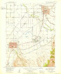
 1998 Spanish Fork2002 Print · USGSThe Utah Valley transitions from high forest peaks to a bustling agricultural corridor in the late nineties. Genealogists and historians can trace the growth of Payson and Salem alongside irrigation works like the Salem Canal and the Sugar Refinery.
 - 1998 Map of Payson Lakes, 2002 Print
 1998 Payson Lakes2002 Print · USGSThe high country of the Wasatch Range comes into focus during the late nineties, showcasing a landscape of mountain lakes and forest camps. Trace mining history at the Golden Relief Mine or explore the alpine waters of McClellan Lake and Winward Reservoir.
End of results
Showing maps 1-19 of 19
Top cities near Payson
- Provo historical maps
- Orem historical maps
- Eagle Mountain historical maps
- Spanish Fork historical maps
- Springville historical maps
- Mapleton historical maps
See more
Frequently asked questions
- What are the different types of historical maps available for Payson?
- What is the oldest map of Payson?
- Where can I purchase historical maps of Payson for my home or office?
- Where can I download high-res historical maps of Payson?
- Are there historical topographic maps available for Payson?
- Is there historical aerial imagery available for Payson?
- Where are historical maps of Payson sourced from?