1900s (20th Century) Maps of Fremont, Utah
Explore 8 historic maps of Fremont from the 1900s (20th Century). These maps offer a rare glimpse into what life looked like during the 1900s — showing old roads, neighborhoods, homes, and landmarks that have changed or disappeared over time.
Whether you're researching your family's past, planning a metal detecting trip, or studying how Fremont's landscape evolved across the 1900s, these high-resolution maps are a powerful tool for exploring the history of this region.
- Focus on a specific era: All maps on this page are from the 1900s, giving you a focused view of this time period.
- See what’s changed: Compare century-old streets, trails, and buildings to today's modern landscape using overlays and satellite layers.
- Research with precision: Use these maps for genealogy, historical research, land use analysis, or educational projects.
- View, download, or print: Maps are fully viewable online in high resolution, and can be downloaded or printed for your own records.
Start exploring Fremont's history through authentic maps from the 1900s. This is your window into the past.
Fremont, UT maps
(8)- 1952 Map of Loa 1 NE, 1973 Print
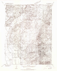 1952 Loa 1 NE1973 Print · USGSWayne County ranching and remote mountain terrain define this mid-century survey of the Utah high plateaus. Genealogists and historians can trace irrigation networks like the High Line Ditch and find landmarks such as the Lyman Cemetery and Fremont village.
 - 1956 Map of Salina
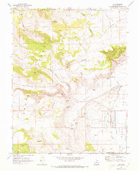
 1956 Salina1956 Print · USGSCentral Utah in the mid-fifties reveals a landscape of high plateaus and desert basins before the modern highway era. Researchers can trace the ranching and mining roots of Hanksville and Loa or locate the Lucky Strike Mine near the San Rafael Swell.5 unique versions available
 - 1960 Map of Salina
 1960 Salina1960 Print · USGSThe high plateaus and canyonlands of south-central Utah appear in the early sixties as a region of remote ranching towns and developing parklands. Researchers can trace historic settlements like Fruita and Loa or locate the uranium mines and the tracks of the Denver and Rio Grande Western RR.2 unique versions available
 - 1962 Map of Salina
 1962 Salina1962 Print · USGSSevier County and the surrounding desert wilderness appear here in the early sixties as a network of isolated river valley towns and high-altitude forests. Researchers can locate remote landmarks like Fruita, trace the Denver & Rio Grande Western RR, and find backcountry sites like the Aquarius Ranger Station.
 - 1967 Map of Lyman, 1973 Print
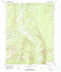 1967 Lyman1973 Print · USGSThe high country of the Uinta and Summit County border is captured here in the late sixties as the Meeks Cabin Reservoir began to fill. Researchers can locate the Old Blacks Fork Commissary, the Youth Camp at Lyman Lake, and the remote East Fork Blacks Fork Guard Station.
 - 1969 Map of Loa, 1973 Print
 1969 Loa1973 Print · USGSRabbit Valley and the high plateaus of Wayne County are captured here in the late sixties. Researchers can trace the water-management history of Loa through local features like the Fish Hatchery, Allred Ditch, and the community Rodeo Grounds.2 unique versions available
 - 1980 Map of Loa
 1980 Loa1980 Print · USGSCentral Utah's high plateaus and the Fremont River corridor are captured here during the 1980s, showcasing a landscape of high-elevation reservoirs and remote ranching outposts. Genealogists can trace family names and early settlements from Loa and Teasdale to the orchards of Fruita.2 unique versions available
 - 1985 Map of Lyman
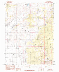 1985 Lyman1985 Print · USGSWayne County settlements and high desert water systems are captured in the mid-eighties as ranchers managed the eastern edge of the plateau. Local historians can trace early water infrastructure like the Highline Ditch and family-named landmarks including Tidwell Spring and Burnt Springs.
End of results
Showing maps 1-8 of 8
Top cities near Fremont
Frequently asked questions
- What are the different types of historical maps available for Fremont?
- What is the oldest map of Fremont?
- Where can I purchase historical maps of Fremont for my home or office?
- Where can I download high-res historical maps of Fremont?
- Are there historical topographic maps available for Fremont?
- Is there historical aerial imagery available for Fremont?
- Where are historical maps of Fremont sourced from?