1990s Maps of Trappers Crossing, Utah
Explore 2 historic maps of Trappers Crossing from the 1990s. These maps offer a rare glimpse into what life looked like during the 1990s — showing old roads, neighborhoods, homes, and landmarks that have changed or disappeared over time.
Whether you're researching your family's past, planning a metal detecting trip, or studying how Trappers Crossing's landscape evolved across the 1990s, these high-resolution maps are a powerful tool for exploring the history of this region.
- Focus on a specific era: All maps on this page are from the 1990s, giving you a focused view of this time period.
- See what’s changed: Compare century-old streets, trails, and buildings to today's modern landscape using overlays and satellite layers.
- Research with precision: Use these maps for genealogy, historical research, land use analysis, or educational projects.
- View, download, or print: Maps are fully viewable online in high resolution, and can be downloaded or printed for your own records.
Start exploring Trappers Crossing's history through authentic maps from the 1990s. This is your window into the past.
Trappers Crossing, UT maps
(2)- 1992 Map of Snow Basin
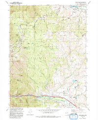 1992 Snow Basin1992 Print · USGSThe high alpine bowls and Weber Valley settlements are captured here in the early nineties as recreation and local infrastructure expanded. Researchers can trace family sites at Mountain Green, locate the Mtn Green Cemetery, or explore the development of Snow Basin.
 - 1998 Map of Snow Basin, 2001 Print
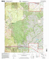 1998 Snow Basin2001 Print · USGSMorgan County is shown in the late 1990s as the high-elevation terrain prepared for the Olympic winter games. Researchers can trace the development of the Snowbasin Ski Area and locate local landmarks like Mountain Green and the Strawberry Mine.
End of results
Showing maps 1-2 of 2
Top cities near Trappers Crossing
- Ogden historical maps
- Layton historical maps
- Kaysville historical maps
- Clearfield historical maps
- North Ogden historical maps
- Brigham City historical maps
See more
Frequently asked questions
- What are the different types of historical maps available for Trappers Crossing?
- What is the oldest map of Trappers Crossing?
- Where can I purchase historical maps of Trappers Crossing for my home or office?
- Where can I download high-res historical maps of Trappers Crossing?
- Are there historical topographic maps available for Trappers Crossing?
- Is there historical aerial imagery available for Trappers Crossing?
- Where are historical maps of Trappers Crossing sourced from?