1980s Maps of Washington Heights, Washington
Explore 2 historic maps of Washington Heights from the 1980s. These maps offer a rare glimpse into what life looked like during the 1980s — showing old roads, neighborhoods, homes, and landmarks that have changed or disappeared over time.
Whether you're researching your family's past, planning a metal detecting trip, or studying how Washington Heights's landscape evolved across the 1980s, these high-resolution maps are a powerful tool for exploring the history of this region.
- Focus on a specific era: All maps on this page are from the 1980s, giving you a focused view of this time period.
- See what’s changed: Compare century-old streets, trails, and buildings to today's modern landscape using overlays and satellite layers.
- Research with precision: Use these maps for genealogy, historical research, land use analysis, or educational projects.
- View, download, or print: Maps are fully viewable online in high resolution, and can be downloaded or printed for your own records.
Start exploring Washington Heights's history through authentic maps from the 1980s. This is your window into the past.
Washington Heights, Washington maps
(2)- 1981 Map of Washington
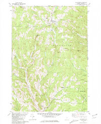 1981 Washington1981 Print · USGSCentral Vermont's rural landscape is captured here in the early eighties, showcasing the intersection of small upland hamlets and managed timberlands. Genealogists and local historians can locate several family cemeteries such as Fish Cem and Clough Cem, or trace the winding roads connecting Washington to Kennedy Corners.2 unique versions available
 - 1988 Map of Montpelier
 1988 Montpelier1988 Print · USGSThe area surrounding Vermont’s capital city appears here during the early 1940s, showing the vital rail-and-river network. Genealogists can trace family names across a dozen district schools and rural sites like Middlesex Center and the Talc Mine.2 unique versions available
End of results
Showing maps 1-2 of 2
Top cities near Washington Heights
- Barre historical maps
- Montpelier historical maps
- Northfield historical maps
- Waterbury historical maps
- Randolph historical maps
- Williamstown historical maps
See more
Frequently asked questions
- What are the different types of historical maps available for Washington Heights?
- What is the oldest map of Washington Heights?
- Where can I purchase historical maps of Washington Heights for my home or office?
- Where can I download high-res historical maps of Washington Heights?
- Are there historical topographic maps available for Washington Heights?
- Is there historical aerial imagery available for Washington Heights?
- Where are historical maps of Washington Heights sourced from?