1960s Maps of Craigsville, Virginia
Explore 2 historic maps of Craigsville from the 1960s. These maps offer a rare glimpse into what life looked like during the 1960s — showing old roads, neighborhoods, homes, and landmarks that have changed or disappeared over time.
Whether you're researching your family's past, planning a metal detecting trip, or studying how Craigsville's landscape evolved across the 1960s, these high-resolution maps are a powerful tool for exploring the history of this region.
- Focus on a specific era: All maps on this page are from the 1960s, giving you a focused view of this time period.
- See what’s changed: Compare century-old streets, trails, and buildings to today's modern landscape using overlays and satellite layers.
- Research with precision: Use these maps for genealogy, historical research, land use analysis, or educational projects.
- View, download, or print: Maps are fully viewable online in high resolution, and can be downloaded or printed for your own records.
Start exploring Craigsville's history through authentic maps from the 1960s. This is your window into the past.
Craigsville, VA maps
(2)- 1967 Map of Augusta Springs, 1968 Print
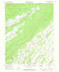 1967 Augusta Springs1968 Print · USGSAugusta County’s valley floor and mountain ridges are documented here in the late sixties, showing the vital link of the Chesapeake and Ohio railroad. Trace local industry and community life through the Estaline Furnace (Ruins), Miller Memorial Ch, and the settlement at Augusta Springs.3 unique versions available
 - 1967 Map of Craigsville, 1969 Print
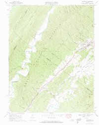 1967 Craigsville1969 Print · USGSAugusta and Rockbridge counties are shown in the late sixties, where the Chesapeake and Ohio railway follows the narrow valley floors. Genealogists and historians can locate the Drive-in Theater, several Quarry sites, and country churches like Lebanon Ch and Little River Ch.2 unique versions available
End of results
Showing maps 1-2 of 2
Top cities near Craigsville
Top neighborhoods of Craigsville
Frequently asked questions
- What are the different types of historical maps available for Craigsville?
- What is the oldest map of Craigsville?
- Where can I purchase historical maps of Craigsville for my home or office?
- Where can I download high-res historical maps of Craigsville?
- Are there historical topographic maps available for Craigsville?
- Is there historical aerial imagery available for Craigsville?
- Where are historical maps of Craigsville sourced from?