1900s (20th Century) Maps of Stokesville, Virginia
Explore 7 historic maps of Stokesville from the 1900s (20th Century). These maps offer a rare glimpse into what life looked like during the 1900s — showing old roads, neighborhoods, homes, and landmarks that have changed or disappeared over time.
Whether you're researching your family's past, planning a metal detecting trip, or studying how Stokesville's landscape evolved across the 1900s, these high-resolution maps are a powerful tool for exploring the history of this region.
- Focus on a specific era: All maps on this page are from the 1900s, giving you a focused view of this time period.
- See what’s changed: Compare century-old streets, trails, and buildings to today's modern landscape using overlays and satellite layers.
- Research with precision: Use these maps for genealogy, historical research, land use analysis, or educational projects.
- View, download, or print: Maps are fully viewable online in high resolution, and can be downloaded or printed for your own records.
Start exploring Stokesville's history through authentic maps from the 1900s. This is your window into the past.
Stokesville, VA maps
(7)- 1944 Map of Parnassus, 1955 Print
 1944 Parnassus1955 Print · USGSThe rural landscapes of Augusta County are shown here during the mid-1940s, where farming valleys meet the high ridges of the national forest. Researchers can locate family landmarks such as Fulton Sch, the towering Natural Chimneys, and small crossroads like Parnassus and Mt Solon.2 unique versions available
 - 1947 Map of Parnassus
 1947 Parnassus1947 Print · USGSThe rural landscape of Augusta and Rockingham counties is captured here in the mid-1940s, showing the transition from fertile valley farms to high mountain ridges. Genealogists and historians can trace family locations near Natural Chimneys, Mt Solon, and the Payne Chapel schoolhouse.2 unique versions available
 - 1949 Map of Charlottesville
 1949 Charlottesville1949 Print · USGSThe Shenandoah Valley and Blue Ridge appear in the late 1940s as a thriving corridor of rail and river commerce. Researchers can trace the mid-century footprints of Harrisonburg, Staunton, and Culpeper alongside the historic routes of the Southern Railway.2 unique versions available
 - 1956 Map of Charlottesville, 1966 Print
 1956 Charlottesville1966 Print · USGSThe Shenandoah Valley and Blue Ridge are captured in detail during the mid-1960s as the modern interstate system began to emerge. Genealogists and historians can trace rail-connected hubs like Waynesboro or follow the river paths of the Rapidan River and Rivanna River.4 unique versions available
 - 1967 Map of Stokesville, 1968 Print
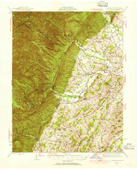
 1967 Stokesville1968 Print · USGSAugusta County in the late sixties reveals a landscape where the Shenandoah Valley meets the mountain wilderness. Genealogists and historians can trace family locations and rural landmarks like Stribling Springs, Whites Store, and the historic Jennings Gap passage.2 unique versions available
 - 1986 Map of Staunton
 1986 Staunton1986 Print · USGSThe Shenandoah Valley and Allegheny Highlands meet in the mid-1980s, revealing a landscape of historic mountain towns and thermal resorts. Genealogists and historians can trace institutional landmarks like Mary Baldwin College or follow the legacy of the Chesapeake and Ohio Railroad through Craigsville and Swoope.2 unique versions available
 - 1999 Map of Stokesville, 2000 Print
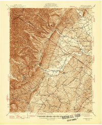
 1999 Stokesville2000 Print · USGSAugusta County remains a landscape of deep forest hollows and mountain gaps at the turn of the millennium. Local researchers can trace the rural footprints of Stokesville, find the site of Whites Store, or locate country churches like Paynes Chapel and Union Ch.
End of results
Showing maps 1-7 of 7
Top cities near Stokesville
- Staunton historical maps
- Bridgewater historical maps
- Verona historical maps
- Dayton historical maps
- Mount Sidney historical maps
- Mount Crawford historical maps
Frequently asked questions
- What are the different types of historical maps available for Stokesville?
- What is the oldest map of Stokesville?
- Where can I purchase historical maps of Stokesville for my home or office?
- Where can I download high-res historical maps of Stokesville?
- Are there historical topographic maps available for Stokesville?
- Is there historical aerial imagery available for Stokesville?
- Where are historical maps of Stokesville sourced from?