1930s Maps of Bristol, Virginia
Explore 9 historic maps of Bristol from the 1930s. These maps offer a rare glimpse into what life looked like during the 1930s — showing old roads, neighborhoods, homes, and landmarks that have changed or disappeared over time.
Whether you're researching your family's past, planning a metal detecting trip, or studying how Bristol's landscape evolved across the 1930s, these high-resolution maps are a powerful tool for exploring the history of this region.
- Focus on a specific era: All maps on this page are from the 1930s, giving you a focused view of this time period.
- See what’s changed: Compare century-old streets, trails, and buildings to today's modern landscape using overlays and satellite layers.
- Research with precision: Use these maps for genealogy, historical research, land use analysis, or educational projects.
- View, download, or print: Maps are fully viewable online in high resolution, and can be downloaded or printed for your own records.
Start exploring Bristol's history through authentic maps from the 1930s. This is your window into the past.
Bristol, VA maps
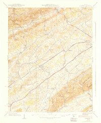
(9)- 1934 Map of Wallace
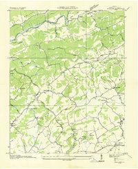 1934 Wallace1934 Print · USGSWashington County at the height of the mid-thirties reveals a landscape of ridge-top schools and valley rail depots before the post-war expansion. Researchers can trace family homesteads near Crabtree Cem or locate the old Mumpower Siding and Bristol Reservoir.
 - 1934 Map of Holston Valley
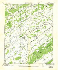
 1934 Holston Valley1934 Print · USGSThe Holston Valley was a landscape of river fords and rural outposts in the mid-1930s. Genealogists and historians can trace family ties through Stuffels Cem, locate old mills like Old Kings Mill, and find river crossings at Shady Ford.
 - 1934 Map of Wyndale
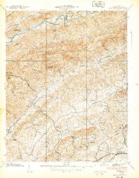
 1934 Wyndale1934 Print · USGSWashington County during the mid-1930s shows a landscape of mountain ridges and fertile valleys connected by the Norfolk and Western railroad. Genealogists can trace rural life through numerous landmarks like Heavenly Rest Chapel, Needmore Sch, and the community of Wyndale.
 - 1934 Map of Bristol
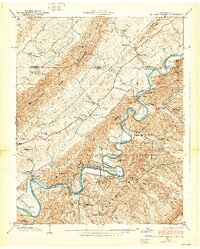
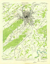 1934 Bristol1934 Print · USGSThe border-straddling community of Bristol is shown at a mid-thirties crossroads of rail and road. Local historians can trace the foundations of the area through the Bristol Landing Field, Beidleman Mill, and dozens of rural schools and churches.
 - 1935 Map of Beaver Creek
 1935 Beaver Creek1935 Print · USGSThe border city of Bristol serves as a bustling rail and highway hub in the mid-1930s. Genealogists and historians can trace family locations near Beidleman Mill, Mountain View Cemetery, and the Twin States Fairgrounds.2 unique versions available
 - 1938 Map of Bristol
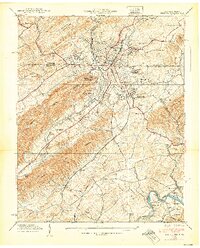 1938 Bristol1938 Print · USGSBristol straddles the Tennessee-Virginia border in the late 1930s, serving as a vital rail and educational hub. Genealogists and local historians can trace the footprint of Sullins College, locate family plots in Mountain View Cemetery, or find the old Beidleman Mill and Ratledge Store.3 unique versions available
 - 1938 Map of Wyndale
 1938 Wyndale1938 Print · USGSWashington County at the height of the New Deal era reveals a rural landscape organized around the Norfolk and Western rail line and valley homesteads. Genealogists can locate specific family hubs like Needmore Sch, Bakers Chapel, and the community of Fractionville.3 unique versions available
 - 1938 Map of Wallace
 1938 Wallace1938 Print · USGSWashington County at the end of the Depression era shows a landscape of mountain ridges and fertile gaps. Genealogists and historians can trace family roots through numerous local landmarks like Wolfrun P O, Fleenor Cem, and Craigs Mill Sch.2 unique versions available
 - 1938 Map of Holston Valley
 1938 Holston Valley1938 Print · USGSThe Holston River valley at the Tennessee-Virginia border in the late 1930s shows a landscape of river fords and mountain ridges. Researchers can trace family history through sites like Stuffels Cem, King Mill, and the Holston Valley Sch before the landscape was altered.2 unique versions available
End of results
Showing maps 1-9 of 9
Top cities of Bristol
Frequently asked questions
- What are the different types of historical maps available for Bristol?
- What is the oldest map of Bristol?
- Where can I purchase historical maps of Bristol for my home or office?
- Where can I download high-res historical maps of Bristol?
- Are there historical topographic maps available for Bristol?
- Is there historical aerial imagery available for Bristol?
- Where are historical maps of Bristol sourced from?