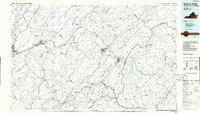
Old Maps of Covington, Virginia
Explore 38 old maps of Covington, spanning from 1887 to today. These high-resolution historic maps reveal how streets, neighborhoods, landmarks, and natural features evolved over time — perfect for genealogy, metal detecting, research, and local history exploration.
What you can do with these maps:
- See how Covington changed over time: Compare historical maps to modern-day views to trace roads, homesites, rail lines & more.
- View detailed metadata: Each map includes creators, publishers, year, scale, and archive source.
- Overlay maps with satellite & LiDAR: Visualize the past alongside modern tools to explore terrain & human change.
- Trusted historical sources: Maps sourced from the USGS, Library of Congress, and other archives.
- Access maps your way: View online, download high-res files, or order prints for personal or research use.
Start exploring old maps of Covington to uncover forgotten places, hidden landmarks, and the deep history beneath your feet.
Covington, VA maps
(38)- 1887 Map of Lewisburg
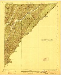
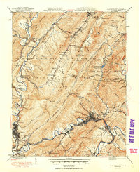
 1887 Lewisburg1887 Print · USGSThe Greenbrier Valley and the Virginia borderlands are captured here in the late nineteenth century during a period of significant rail expansion. Genealogists and historians can trace early mountain settlements like White Sulphur Springs and Ronceverte, or locate specific landmarks like Van Staverns Mill and the Half Way House.
 - 1891 Map of Lewisburg
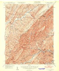
 1891 Lewisburg1891 Print · USGSThe Virginia and West Virginia borderlands are captured here in the late 1880s, documenting a landscape of mountain ridges and burgeoning rail infrastructure. Genealogists and historians can trace family-named landmarks like Van Staverns Mill or follow the route of the Chesapeake and Ohio Railroad through the Alleghany Tunnel.8 unique versions available
 - 1894 Map of Natural Bridge, 1898 Print
 1894 Natural Bridge1898 Print · USGSThe Virginia ridges thrived with iron furnaces and mineral springs during the 1890s. Genealogists and historians can trace the early industrial footprint of Long Dale Furnace and Victoria Mines, or locate local landmarks like Lick Run Ferry and Rapps Mill.7 unique versions available
 - 1913 Map of Eagle Rock
 1913 Eagle Rock1913 Print · USGSBotetourt County at the dawn of the twentieth century shows a landscape tied to the James River and iron-era industry. Genealogists can trace family roots through numerous local landmarks like Salisbury Furnace, Fincastle, and the Fair Grounds.2 unique versions available
 - 1915 Map of Eagle Rock
 1915 Eagle Rock1915 Print · USGSBotetourt and Alleghany counties are captured here during a transitional era of mountain industry and rail expansion. Genealogists can locate family landmarks like Kyles Mills and Comptons Bridge, or trace vanished communities at Lignite and Oriskany.3 unique versions available
 - 1921 Map of Callaghan
 1921 Callaghan1921 Print · USGSThe West Virginia and Virginia borderlands come alive in this early 1920s survey of the mountain gaps and valley drafts. Researchers can trace rural life through numerous country schools like Bound School and landmarks such as Columbia Sulphur Springs and Wileys Crossing.
 - 1923 Map of Callaghan
 1923 Callaghan1923 Print · USGSThe West Virginia and Virginia borderlands come alive in the early 1920s, showing a landscape of remote schoolhouses and mineral springs. Genealogists can trace family footprints near Columbia Sulphur Springs or locate long-gone schools like Wades Draft School and Whites Draft School.3 unique versions available
 - 1945 Map of Clifton Forge, 1963 Print
 1945 Clifton Forge1963 Print · USGSThe rail and river corridors of Alleghany County are captured here at the end of the war, centered on the bustling junction of Clifton Forge. Genealogists and historians can trace old community landmarks like Union Chapel, the Rich Patch Mines, and the Deeds Sch among the ridgelines.2 unique versions available
 - 1946 Map of Callaghan
 1946 Callaghan1946 Print · USGSThe Virginia and West Virginia borderlands are captured here in the mid-1940s, showing the intersection of heavy rail and mountain life. Genealogists and historians can trace old community sites like Hokes Chapel, Dunlap Sch, and the industrial operations at Stack Mine.4 unique versions available
 - 1947 Map of Roanoke, 1948 Print
 1947 Roanoke1948 Print · USGSCentral Virginia in the late 1940s reveals a region defined by its great mountain ridges and the powerful river-and-rail economy connecting Roanoke to Lynchburg. Researchers can trace the path of the Virginian RR and locate historic county seats like Charlotte Court House.2 unique versions available
 - 1949 Map of Callaghan
 1949 Callaghan1949 Print · USGSThe Virginia and West Virginia borderlands come alive in this mid-century survey of the high Allegheny ridges and river valleys. Genealogists and researchers can trace the Chesapeake and Ohio rail line to vanished stops like Backbone Siding or locate family sites near Hokes Chapel and Whites Draft Sch.2 unique versions available
 - 1949 Map of Clifton Forge
 1949 Clifton Forge1949 Print · USGSThe industrial corridor of the Alleghany Highlands thrives in the late 1940s as rail and river networks converge. Researchers can trace historic family-named landmarks and mountain settlements like Carloover, Rich Patch Mines, and Union Chapel.3 unique versions available
 - 1955 Map of Bluefield
 1955 Bluefield1955 Print · USGSThe Central Appalachian borderlands come alive in the mid-fifties, showing the coal and rail networks connecting Bluefield to Beckley. Researchers can trace the industrial landscape of the New River Ordnance Plant and the terrain of Burkes Garden.
 - 1957 Map of Bluefield, 1967 Print
 1957 Bluefield1967 Print · USGSThe heart of Central Appalachia in the mid-fifties is defined by the winding rail lines and river valleys of the coalfields. Researchers can trace the industrial footprints of towns like Welch and Princeton or locate landmarks such as the Bluestone Reservoir and Claytor Lake.2 unique versions available
 - 1959 Map of Roanoke
 1959 Roanoke1959 Print · USGSCentral Virginia and the Blue Ridge appear in great detail during the late fifties, showcasing the transition from mountain industry to Piedmont farmland. Trace the path of the Norfolk and Western railroad or find old river towns like Appomattox and Amelia Court House.
 - 1961 Map of Bluefield
 1961 Bluefield1961 Print · USGSThe coalfields and mountain ridges of southern West Virginia and southwest Virginia are captured in the early sixties. Genealogists can trace family ties through rail-linked towns like Princeton and Richlands or along the shores of Bluestone Reservoir.
 - 1962 Map of Strom, 1963 Print
 1962 Strom1963 Print · USGSBotetourt and Alleghany counties in the early sixties show a landscape shaped by iron history and mountain river life. Researchers can find numerous family cemeteries like Rose Hill Cem, early industrial sites at Roaring Run Furnace, and small settlements like Strom and Lignite.4 unique versions available
 - 1962 Map of Covington, 1964 Print
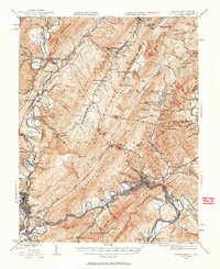
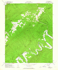
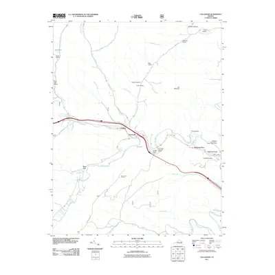
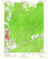 1962 Covington1964 Print · USGSAlleghany County industry and Appalachian topography meet in the early sixties along the Jackson River corridor. Researchers can trace the neighborhoods of Covington, locate family plots at Smith Cem, or identify the footprints of the Rich Patch Mines and Watson High Sch.4 unique versions available
 - 1963 Map of Roanoke
 1963 Roanoke1963 Print · USGSCentral Virginia and the Blue Ridge front appear here in the early sixties, caught between their deep railroad roots and new postwar developments. Genealogists and historians can trace the rail lines of the Norfolk and Western through towns like Bedford and Altavista, or locate family landmarks near Smith Mountain Lake.
 - 1966 Map of Callaghan, 1967 Print
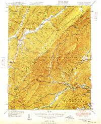
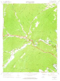 1966 Callaghan1967 Print · USGSAlleghany County in the mid-1960s shows a landscape defined by its mountain ridges and the vital Chesapeake and Ohio rail line. Researchers can trace family sites at Helmintoller Cem, locate rural landmarks like Fletcher Chapel, and see the historic Covered Bridge.2 unique versions available
 - 1971 Map of Roanoke, 1977 Print
 1971 Roanoke1977 Print · USGSThe Virginia Piedmont and Blue Ridge mountains meet in this early 1970s landscape of river valleys and rail hubs. Researchers can trace historic transportation routes and landmarks like the Appomattox Court House Nat Hist Pk, the Peaks of Otter, and Amelia Court House.2 unique versions available
 - 1984 Map of Lewisburg, 1985 Print
 1984 Lewisburg1985 Print · USGSThe Greenbrier Valley in the mid-eighties shows a landscape of river-town commerce, mountain agriculture, and major institutional landmarks. Researchers can trace the rail corridors of the Chesapeake and Ohio and locate sites like the Federal Reformatory for Women and the Sam Black Church.2 unique versions available
 - 1986 Map of Buena Vista
 1986 Buena Vista1986 Print · USGSThe mid-eighties landscape around Rockbridge County comes alive in this survey of the Blue Ridge and Allegheny foothills. Researchers can trace the legacy of institutions like Washington and Lee University or follow the historic Chesapeake and Ohio Railway through Clifton Forge.2 unique versions available
 - 2011 Map of Callaghan, 2011 Print
 2011 Callaghan2011 Print · USGSCovers Covington, including Callaghan, Moss Run, and other nearby areas
 - 2011 Map of Covington, 2011 Print
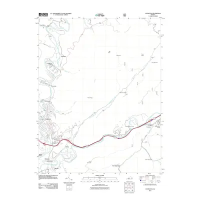 2011 Covington2011 Print · USGSCovers Covington, including Mallow, Low Moor, and other nearby areas
Showing maps 1-25 of 38
Top cities of Covington
Frequently asked questions
- What are the different types of historical maps available for Covington?
- What is the oldest map of Covington?
- Where can I purchase historical maps of Covington for my home or office?
- Where can I download high-res historical maps of Covington?
- Are there historical topographic maps available for Covington?
- Is there historical aerial imagery available for Covington?
- Where are historical maps of Covington sourced from?