1960s Maps of Glen Lyn, Virginia
Explore 3 historic maps of Glen Lyn from the 1960s. These maps offer a rare glimpse into what life looked like during the 1960s — showing old roads, neighborhoods, homes, and landmarks that have changed or disappeared over time.
Whether you're researching your family's past, planning a metal detecting trip, or studying how Glen Lyn's landscape evolved across the 1960s, these high-resolution maps are a powerful tool for exploring the history of this region.
- Focus on a specific era: All maps on this page are from the 1960s, giving you a focused view of this time period.
- See what’s changed: Compare century-old streets, trails, and buildings to today's modern landscape using overlays and satellite layers.
- Research with precision: Use these maps for genealogy, historical research, land use analysis, or educational projects.
- View, download, or print: Maps are fully viewable online in high resolution, and can be downloaded or printed for your own records.
Start exploring Glen Lyn's history through authentic maps from the 1960s. This is your window into the past.
Glen Lyn, VA maps
(3)- 1961 Map of Bluefield
 1961 Bluefield1961 Print · USGSThe coalfields and mountain ridges of southern West Virginia and southwest Virginia are captured in the early sixties. Genealogists can trace family ties through rail-linked towns like Princeton and Richlands or along the shores of Bluestone Reservoir.
 - 1965 Map of Peterstown, 1966 Print
 1965 Peterstown1966 Print · USGSMonroe County and the Virginia borderlands are shown in the mid-sixties just as the waters of Bluestone Reservoir reshaped the valley. Trace the old pathways of the New River and find family landmarks like Mt Carmel Cem or Thompson Chapel.3 unique versions available
 - 1965 Map of Narrows, 1966 Print
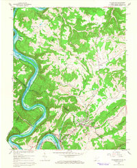
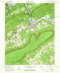 1965 Narrows1966 Print · USGSThe Virginia and West Virginia borderlands in the mid-1960s show a rugged mountain economy defined by the New River and its rail lines. Local researchers can locate family sites like Blankenship Cem or trace the early Appalachian Trail over Pearis Mountain.4 unique versions available
End of results
Showing maps 1-3 of 3
Top cities near Glen Lyn
- Princeton historical maps
- Pearisburg historical maps
- Narrows historical maps
- Athens historical maps
- Pembroke historical maps
- Rich Creek historical maps
See more
Frequently asked questions
- What are the different types of historical maps available for Glen Lyn?
- What is the oldest map of Glen Lyn?
- Where can I purchase historical maps of Glen Lyn for my home or office?
- Where can I download high-res historical maps of Glen Lyn?
- Are there historical topographic maps available for Glen Lyn?
- Is there historical aerial imagery available for Glen Lyn?
- Where are historical maps of Glen Lyn sourced from?