1900s (20th Century) Maps of Pembroke, Virginia
Explore 10 historic maps of Pembroke from the 1900s (20th Century). These maps offer a rare glimpse into what life looked like during the 1900s — showing old roads, neighborhoods, homes, and landmarks that have changed or disappeared over time.
Whether you're researching your family's past, planning a metal detecting trip, or studying how Pembroke's landscape evolved across the 1900s, these high-resolution maps are a powerful tool for exploring the history of this region.
- Focus on a specific era: All maps on this page are from the 1900s, giving you a focused view of this time period.
- See what’s changed: Compare century-old streets, trails, and buildings to today's modern landscape using overlays and satellite layers.
- Research with precision: Use these maps for genealogy, historical research, land use analysis, or educational projects.
- View, download, or print: Maps are fully viewable online in high resolution, and can be downloaded or printed for your own records.
Start exploring Pembroke's history through authentic maps from the 1900s. This is your window into the past.
Pembroke, VA maps
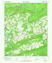
(10)- 1923 Map of Pearisburg
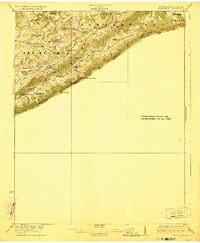 1923 Pearisburg1923 Print · USGSThe West Virginia and Virginia state line follows the high crest of Peters Mountain in the early 1920s. Genealogists can trace a remarkable concentration of rural education and faith at sites like Oak Hill School and Green Valley Church.3 unique versions available
 - 1932 Map of Pearisburg
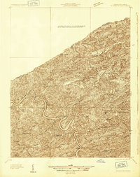 1932 Pearisburg1932 Print · USGSGiles County in the early 1930s is defined by the winding New River and its mountain-bound communities. Genealogists can trace early homesteads and local institutions through Goodwins Ferry, Hoges Store, and several named schools like McGrady Sch.3 unique versions available
 - 1937 Map of Pearisburg
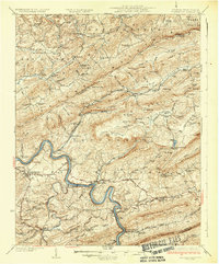 1937 Pearisburg1937 Print · USGSGiles County at the onset of the late 1930s reveals a rugged mountain landscape where the New River dictates the path of commerce and travel. Genealogists can trace family roots through numerous rural landmarks like Hoges Store, Goodwins Ferry, and the remote McClardy School.3 unique versions available
 - 1955 Map of Bluefield
 1955 Bluefield1955 Print · USGSThe Central Appalachian borderlands come alive in the mid-fifties, showing the coal and rail networks connecting Bluefield to Beckley. Researchers can trace the industrial landscape of the New River Ordnance Plant and the terrain of Burkes Garden.
 - 1957 Map of Bluefield, 1967 Print
 1957 Bluefield1967 Print · USGSThe heart of Central Appalachia in the mid-fifties is defined by the winding rail lines and river valleys of the coalfields. Researchers can trace the industrial footprints of towns like Welch and Princeton or locate landmarks such as the Bluestone Reservoir and Claytor Lake.2 unique versions available
 - 1961 Map of Bluefield
 1961 Bluefield1961 Print · USGSThe coalfields and mountain ridges of southern West Virginia and southwest Virginia are captured in the early sixties. Genealogists can trace family ties through rail-linked towns like Princeton and Richlands or along the shores of Bluestone Reservoir.
 - 1965 Map of Pearisburg, 1966 Print
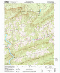
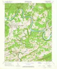 1965 Pearisburg1966 Print · USGSGiles County settlements and industrial sites along the New River are captured here in the mid-sixties. Researchers can locate family landmarks such as the Mason-French Cem, the path of the Appalachian Trail, and rail hubs like Kimballton.3 unique versions available
 - 1965 Map of Eggleston, 1967 Print
 1965 Eggleston1967 Print · USGSGiles County in the mid-1960s is characterized by the winding New River corridor and the high Appalachian plateaus of the Jefferson National Forest. Local historians can trace riverside rail life at Eggleston and find family landmarks like Hoges Chapel and Goodwins Ferry.3 unique versions available
 - 1982 Map of Radford, 1983 Print
 1982 Radford1983 Print · USGSThe New River Valley and surrounding highlands are shown during a period of significant regional growth in the early eighties. Genealogists and historians can trace the development of VPI, locate historic sites like Yellow Sulphur Springs, and follow the Norfolk and Western rail lines through the gaps.2 unique versions available
 - 1998 Map of Eggleston, 2000 Print
 1998 Eggleston2000 Print · USGSNear the turn of the millennium, this portion of Giles County shows a landscape of mountain ridges and river settlements. Genealogists and historians can trace family sites at Goodwins Ferry, Hoges Chapel, and the Lucas Memorial Cem Ch.
End of results
Showing maps 1-10 of 10
Top cities near Pembroke
- Blacksburg historical maps
- Christiansburg historical maps
- Radford historical maps
- Merrimac historical maps
- Pearisburg historical maps
- Dublin historical maps
See more
Frequently asked questions
- What are the different types of historical maps available for Pembroke?
- What is the oldest map of Pembroke?
- Where can I purchase historical maps of Pembroke for my home or office?
- Where can I download high-res historical maps of Pembroke?
- Are there historical topographic maps available for Pembroke?
- Is there historical aerial imagery available for Pembroke?
- Where are historical maps of Pembroke sourced from?