1970s Maps of Piney Grove, Virginia
Explore 1 historic maps of Piney Grove from the 1970s. These maps offer a rare glimpse into what life looked like during the 1970s — showing old roads, neighborhoods, homes, and landmarks that have changed or disappeared over time.
Whether you're researching your family's past, planning a metal detecting trip, or studying how Piney Grove's landscape evolved across the 1970s, these high-resolution maps are a powerful tool for exploring the history of this region.
- Focus on a specific era: All maps on this page are from the 1970s, giving you a focused view of this time period.
- See what’s changed: Compare century-old streets, trails, and buildings to today's modern landscape using overlays and satellite layers.
- Research with precision: Use these maps for genealogy, historical research, land use analysis, or educational projects.
- View, download, or print: Maps are fully viewable online in high resolution, and can be downloaded or printed for your own records.
Start exploring Piney Grove's history through authentic maps from the 1970s. This is your window into the past.
Piney Grove, VA maps
(1)- 1979 Map of Scottsburg, 1982 Print
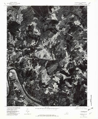 1979 Scottsburg1982 Print · USGSThe James River corridor near Scottsville is captured in detail during the late 1970s, showing the intersection of river life and upland farming. Researchers can trace land use patterns near Scottsville or locate rural sites at Antioch and Nicholas.
End of results
Showing maps 1-1 of 1
Top cities near Piney Grove
- South Boston historical maps
- Halifax historical maps
- Mountain Road historical maps
- Riverdale historical maps
- Cluster Springs historical maps
- Drakes Branch historical maps
See more
Frequently asked questions
- What are the different types of historical maps available for Piney Grove?
- What is the oldest map of Piney Grove?
- Where can I purchase historical maps of Piney Grove for my home or office?
- Where can I download high-res historical maps of Piney Grove?
- Are there historical topographic maps available for Piney Grove?
- Is there historical aerial imagery available for Piney Grove?
- Where are historical maps of Piney Grove sourced from?