1970s Maps of Crown Grant, Henrico County
Explore 3 historic maps of Crown Grant from the 1970s. These maps offer a rare glimpse into what life looked like during the 1970s — showing old roads, neighborhoods, homes, and landmarks that have changed or disappeared over time.
Whether you're researching your family's past, planning a metal detecting trip, or studying how Crown Grant's landscape evolved across the 1970s, these high-resolution maps are a powerful tool for exploring the history of this region.
- Focus on a specific era: All maps on this page are from the 1970s, giving you a focused view of this time period.
- See what’s changed: Compare century-old streets, trails, and buildings to today's modern landscape using overlays and satellite layers.
- Research with precision: Use these maps for genealogy, historical research, land use analysis, or educational projects.
- View, download, or print: Maps are fully viewable online in high resolution, and can be downloaded or printed for your own records.
Start exploring Crown Grant's history through authentic maps from the 1970s. This is your window into the past.
Crown Grant, Henrico County maps
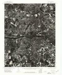
(3)- 1973 Map of Richmond, 1974 Print
 1973 Richmond1974 Print · USGSThe Virginia Tidewater and Piedmont come alive in the early seventies, showcasing a region defined by its great rivers and massive military installations. Researchers can trace the mid-century growth of Richmond or locate family sites near Amelia Court House and Highland Springs.2 unique versions available
 - 1974 Map of Bon Air, 1977 Print
 1974 Bon Air1977 Print · USGSThe suburbs of Richmond and Chesterfield County are captured during a mid-seventies growth boom along the James River. Genealogists and local historians can trace the 1970s footprint of Bon Air and the western reaches of Richmond.
 - 1974 Map of Glen Allen, 1977 Print
 1974 Glen Allen1977 Print · USGSHenrico County undergoes significant suburban transformation in the mid-1970s. Genealogists and local researchers can trace the growth of Glen Allen and the winding course of the Chickahominy River using detailed aerial imagery.
End of results
Showing maps 1-3 of 3
Frequently asked questions
- What are the different types of historical maps available for Crown Grant?
- What is the oldest map of Crown Grant?
- Where can I purchase historical maps of Crown Grant for my home or office?
- Where can I download high-res historical maps of Crown Grant?
- Are there historical topographic maps available for Crown Grant?
- Is there historical aerial imagery available for Crown Grant?
- Where are historical maps of Crown Grant sourced from?