Old Maps of Henry County, Virginia
Explore 40 old maps of Henry County, spanning from 1922 to today. These high-resolution historic maps reveal how streets, neighborhoods, landmarks, and natural features evolved over time — perfect for genealogy, metal detecting, research, and local history exploration.
What you can do with these maps:
- See how Henry County changed over time: Compare historical maps to modern-day views to trace roads, homesites, rail lines & more.
- View detailed metadata: Each map includes creators, publishers, year, scale, and archive source.
- Overlay maps with satellite & LiDAR: Visualize the past alongside modern tools to explore terrain & human change.
- Trusted historical sources: Maps sourced from the USGS, Library of Congress, and other archives.
- Access maps your way: View online, download high-res files, or order prints for personal or research use.
Start exploring old maps of Henry County to uncover forgotten places, hidden landmarks, and the deep history beneath your feet.
Henry County, VA maps
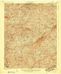
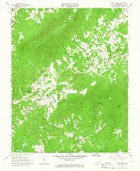
(40)- 1922 Map of Callands
 1922 Callands1922 Print · USGSCovers Henry County, including Union Hall, Penhook, and other nearby areas
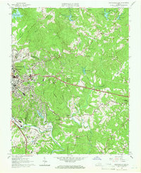
 - 1924 Map of Martinsville
 1924 Martinsville1924 Print · USGSCovers Henry County, including Eden, Martinsville, and other nearby areas
 - 1924 Map of Draper
 1924 Draper1924 Print · USGSCovers Henry County, including Eden, Axton, and other nearby areas
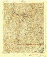
 - 1924 Map of Callands
 1924 Callands1924 Print · USGSCovers Henry County, including Union Hall, Penhook, and other nearby areas3 unique versions available
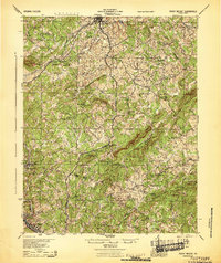
 - 1925 Map of Rocky Mount
 1925 Rocky Mount1925 Print · USGSCovers Henry County, including Rocky Mount, Henry Fork, and other nearby areas
 - 1926 Map of Martinsville
 1926 Martinsville1926 Print · USGSCovers Henry County, including Eden, Martinsville, and other nearby areas2 unique versions available
 - 1926 Map of Critz
 1926 Critz1926 Print · USGSCovers Henry County, including Bassett, Stuart, and other nearby areas2 unique versions available
 - 1926 Map of Draper
 1926 Draper1926 Print · USGSCovers Henry County, including Eden, Axton, and other nearby areas3 unique versions available
 - 1927 Map of Rocky Mount
 1927 Rocky Mount1927 Print · USGSCovers Henry County, including Rocky Mount, Henry Fork, and other nearby areas3 unique versions available
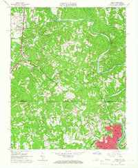
 - 1927 Map of Martinsville, 1942 Print
 1927 Martinsville1942 Print · USGSCovers Henry County, including Eden, Martinsville, and other nearby areas2 unique versions available
 - 1928 Map of Critz
 1928 Critz1928 Print · USGSCovers Henry County, including Bassett, Stuart, and other nearby areas3 unique versions available
 - 1944 Map of Martinsville
 1944 Martinsville1944 Print · USGSCovers Henry County, including Eden, Martinsville, and other nearby areas
 - 1944 Map of Rocky Mount
 1944 Rocky Mount1944 Print · USGSCovers Henry County, including Rocky Mount, Henry Fork, and other nearby areas
 - 1944 Map of Draper
 1944 Draper1944 Print · USGSCovers Henry County, including Eden, Axton, and other nearby areas
 - 1944 Map of Callands
 1944 Callands1944 Print · USGSCovers Henry County, including Union Hall, Penhook, and other nearby areas
 - 1953 Map of Winston-Salem, 1974 Print
 1953 Winston-Salem1974 Print · USGSCovers Henry County, including Greensboro, Winston-Salem, and other nearby areas2 unique versions available
 - 1953 Map of Greensboro, 1981 Print
 1953 Greensboro1981 Print · USGSCovers Henry County, including Greensboro, Durham, and other nearby areas
 - 1954 Map of Greensboro
 1954 Greensboro1954 Print · USGSCovers Henry County, including Greensboro, Durham, and other nearby areas
 - 1955 Map of Winston-Salem
 1955 Winston-Salem1955 Print · USGSCovers Henry County, including Greensboro, Winston-Salem, and other nearby areas
 - 1957 Map of Endicott, 1959 Print
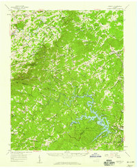 1957 Endicott1959 Print · USGSCovers Henry County, including Bassett, Ferrum, and other nearby areas2 unique versions available
 - 1962 Map of Winston-Salem
 1962 Winston-Salem1962 Print · USGSCovers Henry County, including Greensboro, Winston-Salem, and other nearby areas
 - 1962 Map of Greensboro
 1962 Greensboro1962 Print · USGSCovers Henry County, including Greensboro, Durham, and other nearby areas
 - 1964 Map of Snow Creek, 1966 Print
 1964 Snow Creek1966 Print · USGSCovers Henry County, including Figsboro, Franklin County, and other nearby areas4 unique versions available
 - 1964 Map of Martinsville East, 1966 Print
 1964 Martinsville East1966 Print · USGSCovers Henry County, including Martinsville, Martinsville, and other nearby areas5 unique versions available
 - 1964 Map of Spray, 1966 Print
 1964 Spray1966 Print · USGSCovers Henry County, including Eden, Ridgeway, and other nearby areas
Showing maps 1-25 of 40
Top cities of Henry County
- Collinsville historical maps
- Stanleytown historical maps
- Bassett historical maps
- Fieldale historical maps
- Oak Level historical maps
- Ridgeway historical maps
See more
Frequently asked questions
- What are the different types of historical maps available for Henry County?
- What is the oldest map of Henry County?
- Where can I purchase historical maps of Henry County for my home or office?
- Where can I download high-res historical maps of Henry County?
- Are there historical topographic maps available for Henry County?
- Is there historical aerial imagery available for Henry County?
- Where are historical maps of Henry County sourced from?