1920s Maps of Henry County, Virginia
Explore 11 historic maps of Henry County from the 1920s. These maps offer a rare glimpse into what life looked like during the 1920s — showing old roads, neighborhoods, homes, and landmarks that have changed or disappeared over time.
Whether you're researching your family's past, planning a metal detecting trip, or studying how Henry County's landscape evolved across the 1920s, these high-resolution maps are a powerful tool for exploring the history of this region.
- Focus on a specific era: All maps on this page are from the 1920s, giving you a focused view of this time period.
- See what’s changed: Compare century-old streets, trails, and buildings to today's modern landscape using overlays and satellite layers.
- Research with precision: Use these maps for genealogy, historical research, land use analysis, or educational projects.
- View, download, or print: Maps are fully viewable online in high resolution, and can be downloaded or printed for your own records.
Start exploring Henry County's history through authentic maps from the 1920s. This is your window into the past.
Henry County, VA maps
(11)- 1922 Map of Callands
 1922 Callands1922 Print · USGSIn the early 1920s, this pocket of rural Virginia was a landscape of river fords, local stores, and family-named mills. Researchers can trace the roots of small communities at Callands and Swansonville or locate long-standing landmarks like Boones Chapel and La Prades Mill.
 - 1924 Map of Martinsville
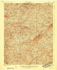
 1924 Martinsville1924 Print · USGSHenry County is shown in the mid-twenties as a thriving industrial corridor along the Smith River. Genealogists can trace family roots through dozens of rural landmarks, from the Bough and Reilly Mill to the Mountain School and Rock Run Church.
 - 1924 Map of Draper
 1924 Draper1924 Print · USGSThe rural Piedmont of Southside Virginia is mapped here during the mid-twenties, showcasing a landscape of small tobacco farms and river-valley settlements. Researchers can trace family sites like Laceys Store, the Soapstone Quarry, and early depots at Leaksville Junction.
 - 1924 Map of Callands
 1924 Callands1924 Print · USGSSouthern Virginia in the early twenties shows a landscape of ridges and river bends at the borders of Franklin, Henry, and Pittsylvania counties. Researchers can trace old family sites and rural infrastructure including Swansons Mill, Burnt Chimney, and the Fralin Bridge over the Pigg River.3 unique versions available
 - 1925 Map of Rocky Mount
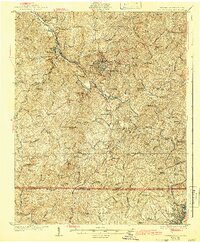
 1925 Rocky Mount1925 Print · USGSFranklin and Henry counties are shown in the mid-twenties, a time when life centered on the river forks and mountain gaps. Trace early industrial footprints near Bassett or locate vanished local hubs like Sydnorsville, Cassells Mill, and Snow Cr School.
 - 1926 Map of Martinsville
 1926 Martinsville1926 Print · USGSHenry County and the Virginia-North Carolina border are captured in the mid-1920s, a period when the Smith River and twin rail lines drove local industry. Researchers can locate dozens of family-named landmarks and institutions like Rough and Ready Mill, Rangeleys Store, and Horse Pasture Church.2 unique versions available
 - 1926 Map of Critz
 1926 Critz1926 Print · USGSAcross the Virginia and North Carolina border in the mid-twenties, this mountain landscape reveals a self-sufficient network of mill seats and rural post offices. Researchers can trace family ties through dozens of landmarks like Blue Mountain School, Kogers Mill, and Patrick Springs Station.2 unique versions available
 - 1926 Map of Draper
 1926 Draper1926 Print · USGSThe Virginia and North Carolina borderlands come alive in the mid-1920s, showing a landscape of small tobacco farms and rail-dependent hamlets. Genealogists can trace family roots through numerous local landmarks like Swansonville, Bachelors Hall Church, and the Danville and Western rail line.3 unique versions available
 - 1927 Map of Rocky Mount
 1927 Rocky Mount1927 Print · USGSThe upland terrain of Franklin and Henry counties is captured here in the mid-1920s, centered on the rail hub of Rocky Mount. Researchers can trace dozens of rural schoolhouses and family-tied landmarks like Cassells Mill, Waidboro PO, and Fork Mountain Church.3 unique versions available
 - 1927 Map of Martinsville, 1942 Print
 1927 Martinsville1942 Print · USGSHenry County and the Virginia-North Carolina border are captured here during the mid-twenties, when the textile and rail economy was transforming the Piedmont. Researchers can trace family sites among dozens of landmarks like Rough and Ready Mill, Fieldale, and Rock Run Church.2 unique versions available
 - 1928 Map of Critz
 1928 Critz1928 Print · USGSPatrick and Henry Counties appear here in the late twenties, showing a transition from the Blue Ridge heights to a valley economy defined by the Danville and Western rail line. Genealogists can trace early homesteads and community hubs like Penns Store, Patrick Springs Station, and Smith Chapel.3 unique versions available
End of results
Showing maps 1-11 of 11
Top cities of Henry County
- Collinsville historical maps
- Stanleytown historical maps
- Bassett historical maps
- Fieldale historical maps
- Oak Level historical maps
- Ridgeway historical maps
See more
Frequently asked questions
- What are the different types of historical maps available for Henry County?
- What is the oldest map of Henry County?
- Where can I purchase historical maps of Henry County for my home or office?
- Where can I download high-res historical maps of Henry County?
- Are there historical topographic maps available for Henry County?
- Is there historical aerial imagery available for Henry County?
- Where are historical maps of Henry County sourced from?