1990s Maps of Ashburn Run, Loudoun County
Explore 2 historic maps of Ashburn Run from the 1990s. These maps offer a rare glimpse into what life looked like during the 1990s — showing old roads, neighborhoods, homes, and landmarks that have changed or disappeared over time.
Whether you're researching your family's past, planning a metal detecting trip, or studying how Ashburn Run's landscape evolved across the 1990s, these high-resolution maps are a powerful tool for exploring the history of this region.
- Focus on a specific era: All maps on this page are from the 1990s, giving you a focused view of this time period.
- See what’s changed: Compare century-old streets, trails, and buildings to today's modern landscape using overlays and satellite layers.
- Research with precision: Use these maps for genealogy, historical research, land use analysis, or educational projects.
- View, download, or print: Maps are fully viewable online in high resolution, and can be downloaded or printed for your own records.
Start exploring Ashburn Run's history through authentic maps from the 1990s. This is your window into the past.
Ashburn Run, Loudoun County maps
(2)- 1994 Map of Sterling, 1998 Print
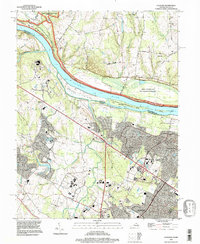 1994 Sterling1998 Print · USGSLoudoun County underwent significant suburban expansion in the mid-nineties as traditional farms gave way to modern residential corridors. Researchers can trace this growth from Sterling to Ashburn Junction, while locating historical features like the W & O D Trail and Selden Island.
 - 1994 Map of Leesburg, 1998 Print
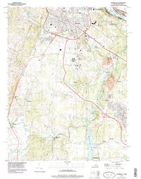 1994 Leesburg1998 Print · USGSLeesburg and the surrounding Loudoun County countryside are captured here in the mid-1990s as the region balanced its rural roots with modern growth. Researchers can trace historic sites like Oatlands and Balls Bluff Battlefield Regional Park alongside the emerging W&OD Trail.
End of results
Showing maps 1-2 of 2
Frequently asked questions
- What are the different types of historical maps available for Ashburn Run?
- What is the oldest map of Ashburn Run?
- Where can I purchase historical maps of Ashburn Run for my home or office?
- Where can I download high-res historical maps of Ashburn Run?
- Are there historical topographic maps available for Ashburn Run?
- Is there historical aerial imagery available for Ashburn Run?
- Where are historical maps of Ashburn Run sourced from?