Old Maps of Madison County, Virginia for Academic Research
Study the evolution of Madison County with 57 high-resolution historic maps. Whether you're teaching, researching, or modeling changes in land use, these maps provide essential visual documentation of urban, environmental, and geographic change.
- Analyze long-term change: Track patterns in development, transportation, and natural features.
- Ideal for environmental or urban studies: Support academic projects with primary historical map data.
- Use in the classroom or lab: Educators and researchers rely on these maps to bring historical context to life.
These maps are a powerful tool for teaching, research, and visualizing how Madison County has changed over the decades.
Madison County, VA maps
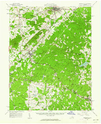
(57)- 1892 Map of Gordonsville, 1899 Print
 1892 Gordonsville1899 Print · USGSCentral Virginia’s railway hubs and mountain gaps come alive in this late nineteenth-century survey. Genealogists and historians can trace the foundations of Charlottesville and the bustling rail junctions at Gordonsville and Orange.6 unique versions available
 - 1893 Map of Luray, 1898 Print
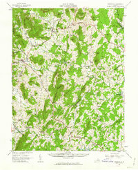
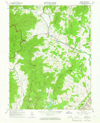
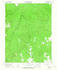
 1893 Luray1898 Print · USGSThe Shenandoah Valley in the 1890s was a land of steep mountain ridges and vital new railways. Genealogists and historians can trace old homesteads and depots along the Shenandoah Valley Railroad or find remote hamlets like Seven Fountains and Browntown.
 - 1905 Map of Luray, 1910 Print
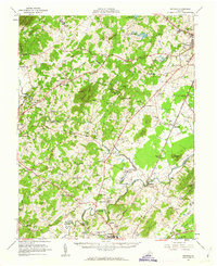
 1905 Luray1910 Print · USGSThe Blue Ridge and Shenandoah Valley are frozen in time just after the turn of the century, showing the critical rail networks and mountain gaps of the period. Genealogists can trace family names and settlements like Luray, Front Royal, and Strasburg along the Shenandoah Valley Railroad.4 unique versions available
 - 1929 Map of Stony Man
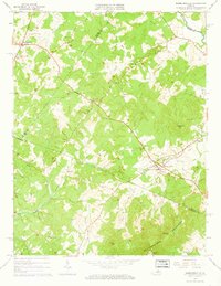
 1929 Stony Man1929 Print · USGSBlue Ridge mountain life and the early development of Shenandoah National Park are captured here just as the park boundary was being established. Genealogists and hikers can trace old mountain routes to the President Hoover Community Sch, locate St Luke Episcopal Mission, or find early trail markers at Sexton Shelter.2 unique versions available
 - 1930 Map of Madison
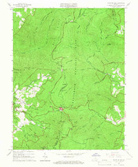
 1930 Madison1930 Print · USGSThe Blue Ridge foothills of Madison and Greene counties are captured here just as Shenandoah National Park was being established. Researchers can trace the early mountain communities around Graves Mill, Criglersville, and the remote Upper Pocosin Mission.3 unique versions available
 - 1933 Map of Stony Man
 1933 Stony Man1933 Print · USGSThe Blue Ridge highlands and Page Valley are captured here during the early years of the national park era. Genealogists and historians can trace family locations through mountain hollows and riverside crossings like Stricklers Ferry, St George Mission, and Baileys Store.3 unique versions available
 - 1933 Map of Madison
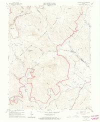
 1933 Madison1933 Print · USGSThe Virginia Piedmont meets the Blue Ridge in the early thirties, just as the national park is taking shape. Genealogists can trace family names across Eppards Mill, The Presidents Camp, and remote schools like the Upper Pocosin Mission.3 unique versions available
 - 1935 Map of Charlottesville
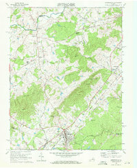
 1935 Charlottesville1935 Print · USGSAlbemarle County's landscape is meticulously detailed in the mid-1930s, centered on the historic crossroads and river forks surrounding the city. Genealogists and local historians can trace family-named landmarks and essential community sites like Monticello, the Rosenwald Sch, and the rail junction at Barboursville.2 unique versions available
 - 1939 Map of Charlottesville
 1939 Charlottesville1939 Print · USGSAlbemarle and Orange Counties come alive in the late 1930s, showing a Piedmont landscape defined by the Southwest Mountains and historic river valleys. Genealogists can locate family landmarks from Monticello to the Rosenwald Sch, alongside dozens of rural churches like Bethany Ch.3 unique versions available
 - 1949 Map of Charlottesville
 1949 Charlottesville1949 Print · USGSThe Shenandoah Valley and Blue Ridge appear in the late 1940s as a thriving corridor of rail and river commerce. Researchers can trace the mid-century footprints of Harrisonburg, Staunton, and Culpeper alongside the historic routes of the Southern Railway.2 unique versions available
 - 1949 Map of Charlottesville, 1962 Print
 1949 Charlottesville1962 Print · USGSMid-century Albemarle County is captured here during a period of steady growth, anchored by the expansion of the Charlottesville area and its surrounding ridges. Researchers can locate rural landmarks like Advance Mills, the Albemarle Training Sch, and the historic Spotswood Trail.
 - 1956 Map of Charlottesville, 1966 Print
 1956 Charlottesville1966 Print · USGSThe Shenandoah Valley and Blue Ridge are captured in detail during the mid-1960s as the modern interstate system began to emerge. Genealogists and historians can trace rail-connected hubs like Waynesboro or follow the river paths of the Rapidan River and Rivanna River.4 unique versions available
 - 1961 Map of Gordonsville, 1962 Print
 1961 Gordonsville1962 Print · USGSCentral Virginia in the early sixties remains a landscape of deep historical roots and rail-based commerce. Genealogists and researchers can trace family names through landmarks like Boswells Tavern, the James Madison Grave, and rural sites like Liberty Mills.2 unique versions available
 - 1961 Map of Sperryville, 1962 Print
 1961 Sperryville1962 Print · USGSVirginia's Piedmont and the Blue Ridge foothills come alive in this early 1960s survey of Rappahannock and Culpeper counties. Genealogists and historians can trace numerous milling communities like Monumental Mills and Peola Mills alongside local landmarks such as Hope Hill Chapel.2 unique versions available
 - 1961 Map of Rapidan, 1963 Print
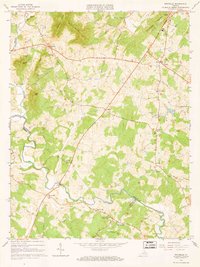
 1961 Rapidan1963 Print · USGSMadison and Culpeper Counties during the early sixties show a transition from a traditional mill-based economy to a modern rural landscape. Genealogists can trace family names at Waylands Mill, Achsah, and Thorofare Mtn Chapel along the Piedmont rivers.2 unique versions available
 - 1964 Map of Barboursville, 1965 Print
 1964 Barboursville1965 Print · USGSThe Virginia Piedmont near Barboursville comes alive in the mid-1960s, showing a landscape of railroad hamlets and rural mountain ridges. Genealogists can trace family landmarks like Thomas Cem and Knights Chapel or explore the Barbour Ruins near the Southern rail line.4 unique versions available
 - 1964 Map of Standardsville, 1966 Print
 1964 Standardsville1966 Print · USGSGreene County and the foothills of the Blue Ridge are captured here in the mid-1960s, showing a landscape of small farming communities and ridge-top parkland. Researchers can locate family sites near McMullen, identify rural churches like Middle River Ch, and trace the paths of Swift Run and the Rapidan River.4 unique versions available
 - 1964 Map of Rochelle, 1966 Print
 1964 Rochelle1966 Print · USGSIn the foothills of the Blue Ridge during the mid-sixties, this area shows a network of established crossroads communities and mountain ridges. Trace the location of family landmarks and local institutions like Repton Mills, Pleasant Grove Ch, and Dawsonville.4 unique versions available
 - 1964 Map of Madison, 1966 Print
 1964 Madison1966 Print · USGSVirginia's Blue Ridge foothills are captured in the mid-sixties, from the protected wilderness of Shenandoah National Park to the streets of Madison. Trace rural family roots near Graves Chapel, Criglersville, and Cedar Hill Cem.5 unique versions available
 - 1965 Map of Big Meadows, 1966 Print
 1965 Big Meadows1966 Print · USGSThe high ridges of Page County meet the valley floor during the mid-1960s, showing the early infrastructure of the National Park. Genealogists and hikers can trace the original routes of the Appalachian Trail and find family landmarks like Trinity Ch, Bethlehem Ch, and Tanners Ridge.4 unique versions available
 - 1965 Map of Thornton Gap, 1966 Print
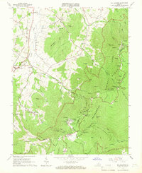
 1965 Thornton Gap1966 Print · USGSShenandoah National Park and the Blue Ridge heights are captured here in the mid-sixties as recreation and mountain life intersected. Researchers can trace the winding Skyline Drive, locate the Morning Star Church, and find old shelters like Byrds Nest No 3.5 unique versions available
 - 1965 Map of Old Rag Mtn, 1966 Print
 1965 Old Rag Mtn1966 Print · USGSShenandoah National Park and the eastern Blue Ridge foothills come to life in the mid-1960s. Researchers can locate the historic Corbin Cabin, trace the original route of the APPALACHIAN TRAIL, and explore the rural road networks of Etlan and Nethers.6 unique versions available
 - 1965 Map of Fletcher, 1967 Print
 1965 Fletcher1967 Print · USGSMadison and Greene Counties are shown in the mid-sixties as the mountain communities of the Blue Ridge foothills intersected with the developing Shenandoah National Park. Researchers can locate family landmarks like the Fletcher Cem, Shiloh Ch, and the presidential retreat at Rapidan Camp.4 unique versions available
 - 1970 Map of Gordonsville, 1972 Print
 1970 Gordonsville1972 Print · USGSGordonsville and the surrounding Virginia Piedmont are captured here in the early seventies as a vital rail crossroads. Researchers can trace family history through sites like James Madison Sch, Blue Run Ch, and the many cemeteries near Old Somerset.3 unique versions available
 - 1971 Map of Brightwood, 1972 Print
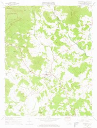
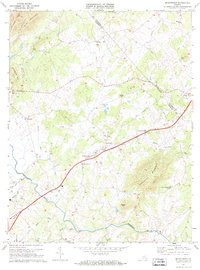 1971 Brightwood1972 Print · USGSMadison and Culpeper Counties are captured in the early seventies, showing a landscape of traditional Piedmont farms and remote mountain hollows. Genealogists can trace family footprints through numerous rural landmarks like Robinson River Ch, Novum, and Thorofare Mountain.2 unique versions available
Showing maps 1-25 of 57
Top cities of Madison County
Frequently asked questions
- What are the different types of historical maps available for Madison County?
- What is the oldest map of Madison County?
- Where can I purchase historical maps of Madison County for my home or office?
- Where can I download high-res historical maps of Madison County?
- Are there historical topographic maps available for Madison County?
- Is there historical aerial imagery available for Madison County?
- Where are historical maps of Madison County sourced from?