1950s Maps of Nicewood, Newport News
Explore 3 historic maps of Nicewood from the 1950s. These maps offer a rare glimpse into what life looked like during the 1950s — showing old roads, neighborhoods, homes, and landmarks that have changed or disappeared over time.
Whether you're researching your family's past, planning a metal detecting trip, or studying how Nicewood's landscape evolved across the 1950s, these high-resolution maps are a powerful tool for exploring the history of this region.
- Focus on a specific era: All maps on this page are from the 1950s, giving you a focused view of this time period.
- See what’s changed: Compare century-old streets, trails, and buildings to today's modern landscape using overlays and satellite layers.
- Research with precision: Use these maps for genealogy, historical research, land use analysis, or educational projects.
- View, download, or print: Maps are fully viewable online in high resolution, and can be downloaded or printed for your own records.
Start exploring Nicewood's history through authentic maps from the 1950s. This is your window into the past.
Nicewood, Newport News maps
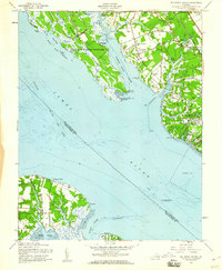
(3)- 1950 Map of Mulberry Island, 1953 Print
 1950 Mulberry Island1953 Print · USGSMid-century coastal Virginia comes into focus as a complex mix of military installations and established local communities. Genealogists and historians can trace Mennonite Colony, find family-named churches like Denbigh Ch, and locate the Prison Farm near the Warwick River.
 - 1957 Map of Mulberry Island, 1960 Print
 1957 Mulberry Island1960 Print · USGSThe mid-century James River waterfront in Virginia shows a mix of heavy military presence and small-scale settlements. Genealogists and historians can trace family locations from the Mennonite Colony to schools and churches like Hidenwood Sch and Providence Ch.
 - 1959 Map of Richmond
 1959 Richmond1959 Print · USGSMid-century Virginia is captured here at its most vital rail and river junctions, from the capital city to the Chesapeake Bay. Genealogists and historians can trace the development of colonial settlements like Williamsburg and military landmarks including Fort Monroe and Camp Lee.
End of results
Showing maps 1-3 of 3
Frequently asked questions
- What are the different types of historical maps available for Nicewood?
- What is the oldest map of Nicewood?
- Where can I purchase historical maps of Nicewood for my home or office?
- Where can I download high-res historical maps of Nicewood?
- Are there historical topographic maps available for Nicewood?
- Is there historical aerial imagery available for Nicewood?
- Where are historical maps of Nicewood sourced from?