Old Maps of Military Circle, Norfolk for Genealogy
Trace your family roots with 14 historic maps of Military Circle. These high-res maps reveal old neighborhoods, homesites, landmarks, and streets — helping you uncover where your ancestors lived and how the area evolved over time.
- Explore historic neighborhoods: Identify where your relatives may have lived in the 1800s or 1900s.
- Compare maps over time: Trace the changes in streets, buildings, and landmarks for multi-generational research.
- Perfect for genealogy & ancestry research: Used by family historians and researchers to map out lineage and migration.
These maps are an incredible resource for exploring your personal connection to Military Circle's past.
Military Circle, Norfolk maps
(14)- 1907 Map of Norfolk
 1907 Norfolk1907 Print · USGSCoastal Virginia is mapped here at the dawn of the twentieth century, during the bustle of the great Jamestown Exposition. Researchers can trace the early rail-and-canal economy through the Albemarle and Chesapeake Canal, the Navy Yard, and historic outposts like the Cape Henry Light.
 - 1918 Map of Cape Henry, 1961 Print
 1918 Cape Henry1961 Print · USGSThe Virginia coast at the close of the First World War shows a landscape of tidal inlets and rail-dependent settlements before modern expansion. Researchers can locate early landmarks like Old Donation Church, London Bridge, and the Dam Neck Mills.
 - 1919 Map of Cape Henry
 1919 Cape Henry1919 Print · USGSIn the years following the Great War, the Virginia coast was a mix of quiet truck farms and emerging resorts. Researchers can trace ancestral lands through dozens of named crossroads like Kempsville and Oceana, or find old houses of worship such as Old Donation Church.7 unique versions available
 - 1948 Map of Kempsville
 1948 Kempsville1948 Print · USGSPrincess Anne County in the late nineteen-forties exhibits a mix of rural homesteads and early suburban development linked by the Norfolk Southern line. Researchers can locate family landmarks like Tipperton Place, Bethel Ch and Cem, and the Princess Anne Co Training Sch.
 - 1953 Map of Norfolk, 1954 Print
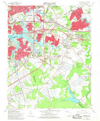
 1953 Norfolk1954 Print · USGSCoastal Virginia and northeastern North Carolina appear here during the post-war industrial boom, showing the critical rail-and-sea connections of Hampton Roads. Genealogists can trace family roots through rural landmarks like Gethsemane Ch, the Caledonia State Prison Farm, and the vast interior of the Dismal Swamp.4 unique versions available
 - 1955 Map of Kempsville, 1958 Print
 1955 Kempsville1958 Print · USGSCoastal Virginia during the mid-fifties shows the evolving landscape of Princess Anne County as urban expansion meets old rural communities. Genealogists and historians can trace family-named sites like Whitehurst Landing, Barrets Corner, and Old Donation Ch.
 - 1965 Map of Kempsville, 1968 Print
 1965 Kempsville1968 Print · USGSCoastal Virginia during the mid-sixties transition shows the rapid growth of Virginia Beach and Norfolk over former farmland. Genealogists and historians can trace suburban development around Kempsville, locate ancestral sites like Jones Cem, or find rural landmarks such as Old St Matthews Ch.6 unique versions available
 - 1985 Map of Norfolk, 1986 Print
 1985 Norfolk1986 Print · USGSThe Tidewater region in the mid-eighties shows the dense urban expansion of the coastal cities alongside the preservation of the Great Dismal Swamp. Researchers can trace rural family-named crossroads and historic transit routes like the Seaboard Coast Line or find Somerton and Lake Drummond.3 unique versions available
 - 1994 Map of Kempsville, 2000 Print
 1994 Kempsville2000 Print · USGSCoastal Virginia's Tidewater region shows a complex weave of suburban expansion and historical roots in the mid-1990s. Genealogists and local historians can trace legacy sites from the Old Donation Ch Cem to the sprawling grounds of Woodlawn Mem Gardens.
 - 2011 Map of Kempsville, 2011 Print
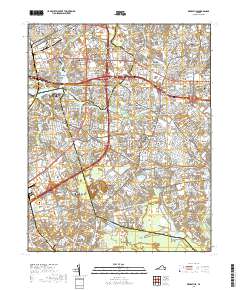
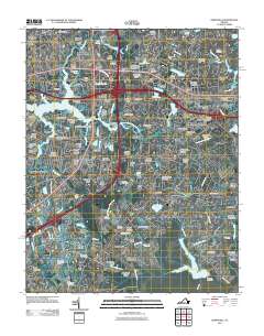 2011 Kempsville2011 Print · USGSCovers Military Circle, including Broad Creek, Coleman Place, and other nearby areas
 - 2013 Map of Kempsville, 2013 Print
 2013 Kempsville2013 Print · USGSCovers Military Circle, including Broad Creek, Coleman Place, and other nearby areas
 - 2016 Map of Kempsville, 2016 Print
 2016 Kempsville2016 Print · USGSCovers Military Circle, including Broad Creek, Coleman Place, and other nearby areas
 - 2019 Map of Kempsville, 2019 Print
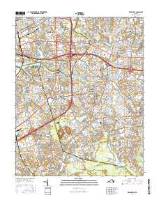
 2019 Kempsville2019 Print · USGSCovers Military Circle, including Broad Creek, Coleman Place, and other nearby areas
 - 2023 Map of Kempsville, 2023 Print
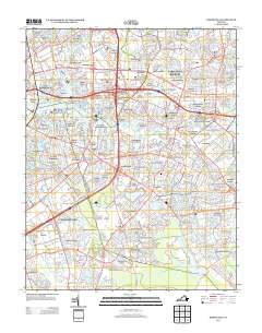
 2023 Kempsville2023 Print · USGSThe interconnected suburbs of Norfolk and Virginia Beach are shown here at their modern height, where historic crossroads meet academic campuses. Genealogists and local historians can locate long-standing sites like Bethel Cem and Thomas Corner amidst the residential growth of Hollywood and Aragona Village.
End of results
Showing maps 1-14 of 14
Frequently asked questions
- What are the different types of historical maps available for Military Circle?
- What is the oldest map of Military Circle?
- Where can I purchase historical maps of Military Circle for my home or office?
- Where can I download high-res historical maps of Military Circle?
- Are there historical topographic maps available for Military Circle?
- Is there historical aerial imagery available for Military Circle?
- Where are historical maps of Military Circle sourced from?