1930s Maps of Montrose Heights, Richmond
Explore 2 historic maps of Montrose Heights from the 1930s. These maps offer a rare glimpse into what life looked like during the 1930s — showing old roads, neighborhoods, homes, and landmarks that have changed or disappeared over time.
Whether you're researching your family's past, planning a metal detecting trip, or studying how Montrose Heights's landscape evolved across the 1930s, these high-resolution maps are a powerful tool for exploring the history of this region.
- Focus on a specific era: All maps on this page are from the 1930s, giving you a focused view of this time period.
- See what’s changed: Compare century-old streets, trails, and buildings to today's modern landscape using overlays and satellite layers.
- Research with precision: Use these maps for genealogy, historical research, land use analysis, or educational projects.
- View, download, or print: Maps are fully viewable online in high resolution, and can be downloaded or printed for your own records.
Start exploring Montrose Heights's history through authentic maps from the 1930s. This is your window into the past.
Montrose Heights, Richmond maps
(2)- 1934 Map of Richmond
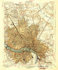
 1934 Richmond1934 Print · USGSRichmond's urban landscape is captured in the mid-1930s, showing a capital city shaped by its riverfront industry and rail network. Researchers can trace the grounds of the State Capitol, find the Broad Street Sta, and locate the Confederate Soldiers Home.2 unique versions available
 - 1939 Map of Richmond
 1939 Richmond1939 Print · USGSRichmond before the war shows a sophisticated urban landscape defined by river power and a complex rail network. Genealogists and historians can locate numerous burial grounds like Hollywood Cemetery or trace the early streetcar path of the Richmond Ashland Electric Ry.2 unique versions available
End of results
Showing maps 1-2 of 2
Frequently asked questions
- What are the different types of historical maps available for Montrose Heights?
- What is the oldest map of Montrose Heights?
- Where can I purchase historical maps of Montrose Heights for my home or office?
- Where can I download high-res historical maps of Montrose Heights?
- Are there historical topographic maps available for Montrose Heights?
- Is there historical aerial imagery available for Montrose Heights?
- Where are historical maps of Montrose Heights sourced from?