1960s Maps of Vinton, Virginia
Explore 4 historic maps of Vinton from the 1960s. These maps offer a rare glimpse into what life looked like during the 1960s — showing old roads, neighborhoods, homes, and landmarks that have changed or disappeared over time.
Whether you're researching your family's past, planning a metal detecting trip, or studying how Vinton's landscape evolved across the 1960s, these high-resolution maps are a powerful tool for exploring the history of this region.
- Focus on a specific era: All maps on this page are from the 1960s, giving you a focused view of this time period.
- See what’s changed: Compare century-old streets, trails, and buildings to today's modern landscape using overlays and satellite layers.
- Research with precision: Use these maps for genealogy, historical research, land use analysis, or educational projects.
- View, download, or print: Maps are fully viewable online in high resolution, and can be downloaded or printed for your own records.
Start exploring Vinton's history through authentic maps from the 1960s. This is your window into the past.
Vinton, VA maps
(4)- 1962 Map of Roanoke
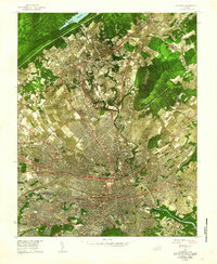 1962 Roanoke1962 Print · USGSMid-century Roanoke and its surrounding valley are captured in this unique experimental aerial mosaic. Genealogists and local historians can trace the early footprints of Vinton, Hollins, and Kingstown, or locate landmarks like Hollins College and the Municipal Airport.
 - 1963 Map of Roanoke
 1963 Roanoke1963 Print · USGSCentral Virginia and the Blue Ridge front appear here in the early sixties, caught between their deep railroad roots and new postwar developments. Genealogists and historians can trace the rail lines of the Norfolk and Western through towns like Bedford and Altavista, or locate family landmarks near Smith Mountain Lake.
 - 1963 Map of Stewartsville, 1964 Print
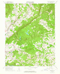 1963 Stewartsville1964 Print · USGSBedford and Botetourt counties meet along the crest of the mountains in the early sixties, as the scenic parkway overlooks a developing valley. Family historians can trace numerous rural churchyards and schools like Mays Memorial Cem and Colonial Sch.4 unique versions available
 - 1963 Map of Roanoke, 1965 Print
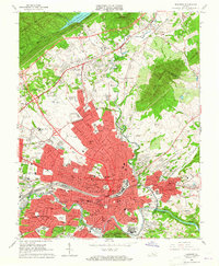 1963 Roanoke1965 Print · USGSRoanoke and its surrounding valley are caught in a moment of rapid suburban and industrial expansion in the early sixties. Researchers can find dozens of family landmarks and local institutions, from Evergreen Cemetery to the campus of Hollins College.6 unique versions available
End of results
Showing maps 1-4 of 4
Top cities near Vinton
- Roanoke historical maps
- Salem historical maps
- Cave Spring historical maps
- Hollins historical maps
- Cloverdale historical maps
- Daleville historical maps
See more
Top neighborhoods of Vinton
- Lynn Haven historical maps
- Timberidge Acres historical maps
- Vinton Heights historical maps
- Southampton historical maps
- Bali Hai historical maps
- Blue Ridge Heights historical maps
See more
Frequently asked questions
- What are the different types of historical maps available for Vinton?
- What is the oldest map of Vinton?
- Where can I purchase historical maps of Vinton for my home or office?
- Where can I download high-res historical maps of Vinton?
- Are there historical topographic maps available for Vinton?
- Is there historical aerial imagery available for Vinton?
- Where are historical maps of Vinton sourced from?