1960s Maps of Moomaw Heights, Roanoke
Explore 2 historic maps of Moomaw Heights from the 1960s. These maps offer a rare glimpse into what life looked like during the 1960s — showing old roads, neighborhoods, homes, and landmarks that have changed or disappeared over time.
Whether you're researching your family's past, planning a metal detecting trip, or studying how Moomaw Heights's landscape evolved across the 1960s, these high-resolution maps are a powerful tool for exploring the history of this region.
- Focus on a specific era: All maps on this page are from the 1960s, giving you a focused view of this time period.
- See what’s changed: Compare century-old streets, trails, and buildings to today's modern landscape using overlays and satellite layers.
- Research with precision: Use these maps for genealogy, historical research, land use analysis, or educational projects.
- View, download, or print: Maps are fully viewable online in high resolution, and can be downloaded or printed for your own records.
Start exploring Moomaw Heights's history through authentic maps from the 1960s. This is your window into the past.
Moomaw Heights, Roanoke maps
(2)- 1961 Map of Bluefield
 1961 Bluefield1961 Print · USGSThe coalfields and mountain ridges of southern West Virginia and southwest Virginia are captured in the early sixties. Genealogists can trace family ties through rail-linked towns like Princeton and Richlands or along the shores of Bluestone Reservoir.
 - 1963 Map of Salem, 1965 Print
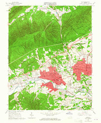 1963 Salem1965 Print · USGSSalem and the western edge of Roanoke are captured here in the early sixties, showing a period of significant suburban and industrial growth. Researchers can locate long-standing institutions like Roanoke College, the grounds of Lakeside Amusement Park, and the Veterans Administration Hospital.4 unique versions available
End of results
Showing maps 1-2 of 2
Frequently asked questions
- What are the different types of historical maps available for Moomaw Heights?
- What is the oldest map of Moomaw Heights?
- Where can I purchase historical maps of Moomaw Heights for my home or office?
- Where can I download high-res historical maps of Moomaw Heights?
- Are there historical topographic maps available for Moomaw Heights?
- Is there historical aerial imagery available for Moomaw Heights?
- Where are historical maps of Moomaw Heights sourced from?