1900s (20th Century) Maps of Watkins Corner, Virginia
Explore 6 historic maps of Watkins Corner from the 1900s (20th Century). These maps offer a rare glimpse into what life looked like during the 1900s — showing old roads, neighborhoods, homes, and landmarks that have changed or disappeared over time.
Whether you're researching your family's past, planning a metal detecting trip, or studying how Watkins Corner's landscape evolved across the 1900s, these high-resolution maps are a powerful tool for exploring the history of this region.
- Focus on a specific era: All maps on this page are from the 1900s, giving you a focused view of this time period.
- See what’s changed: Compare century-old streets, trails, and buildings to today's modern landscape using overlays and satellite layers.
- Research with precision: Use these maps for genealogy, historical research, land use analysis, or educational projects.
- View, download, or print: Maps are fully viewable online in high resolution, and can be downloaded or printed for your own records.
Start exploring Watkins Corner's history through authentic maps from the 1900s. This is your window into the past.
Watkins Corner, VA maps
(6)- 1920 Map of Holland
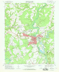
 1920 Holland1920 Print · USGSCoastal plain life at the end of the Great War centers on the river-and-rail hubs of Franklin and Holland. Genealogists can trace family footprints across dozens of country schools like Holmes School and river crossings such as Joyners Bridge and Manning Ferry.2 unique versions available
 - 1943 Map of Holland
 1943 Holland1943 Print · USGSThe Virginia and North Carolina borderlands come alive in this mid-century survey of the Chowan River basin. Local historians can trace a network of river landings and rural schools, from Manning Ferry to the community around Stony Branch Church.
 - 1953 Map of Norfolk, 1954 Print
 1953 Norfolk1954 Print · USGSCoastal Virginia and northeastern North Carolina appear here during the post-war industrial boom, showing the critical rail-and-sea connections of Hampton Roads. Genealogists can trace family roots through rural landmarks like Gethsemane Ch, the Caledonia State Prison Farm, and the vast interior of the Dismal Swamp.4 unique versions available
 - 1957 Map of Holland, 1958 Print
 1957 Holland1958 Print · USGSThe Virginia and North Carolina borderlands come into focus in the mid-fifties, centered on the river city of Franklin and the agricultural community of Holland. Researchers can trace early river crossings like Manning Ferry (Site) and find family roots at Oberry Sch Cem or St Matthews Ch.
 - 1967 Map of Franklin, 1969 Print
 1967 Franklin1969 Print · USGSThe city of Franklin and the surrounding swamplands of the coastal plain come into sharp focus during the late sixties. Genealogists and local historians can trace rural family churches like White Oak Springs Ch and St Johns Ch or the rail-side growth of Hunterdale.5 unique versions available
 - 1985 Map of Norfolk, 1986 Print
 1985 Norfolk1986 Print · USGSThe Tidewater region in the mid-eighties shows the dense urban expansion of the coastal cities alongside the preservation of the Great Dismal Swamp. Researchers can trace rural family-named crossroads and historic transit routes like the Seaboard Coast Line or find Somerton and Lake Drummond.3 unique versions available
End of results
Showing maps 1-6 of 6
Top cities near Watkins Corner
- Franklin historical maps
- Murfreesboro historical maps
- Windsor historical maps
- Courtland historical maps
- Camptown historical maps
- Boykins historical maps
See more
Frequently asked questions
- What are the different types of historical maps available for Watkins Corner?
- What is the oldest map of Watkins Corner?
- Where can I purchase historical maps of Watkins Corner for my home or office?
- Where can I download high-res historical maps of Watkins Corner?
- Are there historical topographic maps available for Watkins Corner?
- Is there historical aerial imagery available for Watkins Corner?
- Where are historical maps of Watkins Corner sourced from?