1960s Maps of Aquia, Stafford County
Explore 3 historic maps of Aquia from the 1960s. These maps offer a rare glimpse into what life looked like during the 1960s — showing old roads, neighborhoods, homes, and landmarks that have changed or disappeared over time.
Whether you're researching your family's past, planning a metal detecting trip, or studying how Aquia's landscape evolved across the 1960s, these high-resolution maps are a powerful tool for exploring the history of this region.
- Focus on a specific era: All maps on this page are from the 1960s, giving you a focused view of this time period.
- See what’s changed: Compare century-old streets, trails, and buildings to today's modern landscape using overlays and satellite layers.
- Research with precision: Use these maps for genealogy, historical research, land use analysis, or educational projects.
- View, download, or print: Maps are fully viewable online in high resolution, and can be downloaded or printed for your own records.
Start exploring Aquia's history through authentic maps from the 1960s. This is your window into the past.
Aquia, Stafford County maps
(3)- 1961 Map of Washington
 1961 Washington1961 Print · USGSThe mid-Atlantic region in the late fifties is presented in remarkable detail, from the Blue Ridge foothills to the Chesapeake Eastern Shore. Researchers can trace historic river landings and military sites like Mount Vernon, Fort Belvoir, and Point Lookout.2 unique versions available
 - 1965 Map of Stafford
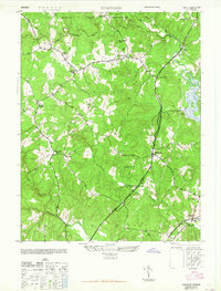 1965 Stafford1965 Print · USGSStafford County at the end of the Second World War shows a rural landscape defined by historic crossroads and a growing military footprint. Genealogists can trace family landmarks and community centers such as Sheltons Shop, Aquia Ch, and the Stafford Training Sch.
 - 1966 Map of Stafford, 1967 Print
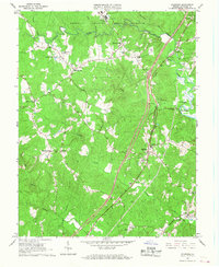 1966 Stafford1967 Print · USGSStafford County is shown in the mid-sixties as military training grounds and early suburban developments began to reshape its rural landscape. Genealogists and historians can trace family-named sites like Sheltons Shop and Moores Corner alongside landmarks like the Crucifix Monument and St William of York Ch.4 unique versions available
End of results
Showing maps 1-3 of 3
Frequently asked questions
- What are the different types of historical maps available for Aquia?
- What is the oldest map of Aquia?
- Where can I purchase historical maps of Aquia for my home or office?
- Where can I download high-res historical maps of Aquia?
- Are there historical topographic maps available for Aquia?
- Is there historical aerial imagery available for Aquia?
- Where are historical maps of Aquia sourced from?