Old Maps of Linkhorn Shores, Virginia for Genealogy
Trace your family roots with 13 historic maps of Linkhorn Shores. These high-res maps reveal old neighborhoods, homesites, landmarks, and streets — helping you uncover where your ancestors lived and how the area evolved over time.
- Explore historic neighborhoods: Identify where your relatives may have lived in the 1800s or 1900s.
- Compare maps over time: Trace the changes in streets, buildings, and landmarks for multi-generational research.
- Perfect for genealogy & ancestry research: Used by family historians and researchers to map out lineage and migration.
These maps are an incredible resource for exploring your personal connection to Linkhorn Shores's past.
Linkhorn Shores, VA maps
(13)- 1907 Map of Norfolk
 1907 Norfolk1907 Print · USGSCoastal Virginia is mapped here at the dawn of the twentieth century, during the bustle of the great Jamestown Exposition. Researchers can trace the early rail-and-canal economy through the Albemarle and Chesapeake Canal, the Navy Yard, and historic outposts like the Cape Henry Light.
 - 1918 Map of Cape Henry, 1961 Print
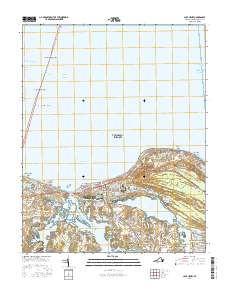
 1918 Cape Henry1961 Print · USGSThe Virginia coast at the close of the First World War shows a landscape of tidal inlets and rail-dependent settlements before modern expansion. Researchers can locate early landmarks like Old Donation Church, London Bridge, and the Dam Neck Mills.
 - 1919 Map of Cape Henry
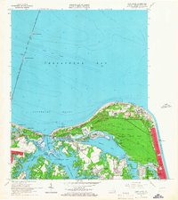
 1919 Cape Henry1919 Print · USGSIn the years following the Great War, the Virginia coast was a mix of quiet truck farms and emerging resorts. Researchers can trace ancestral lands through dozens of named crossroads like Kempsville and Oceana, or find old houses of worship such as Old Donation Church.7 unique versions available
 - 1952 Map of Cape Henry
 1952 Cape Henry1952 Print · USGSThe Virginia coast at the mouth of the Chesapeake comes alive in this mid-century survey of the Cape Henry region. Researchers can trace the layout of Fort Story, the original boundaries of Seashore State Park, and early bayfront communities like Ocean Park.
 - 1953 Map of Norfolk, 1954 Print
 1953 Norfolk1954 Print · USGSCoastal Virginia and northeastern North Carolina appear here during the post-war industrial boom, showing the critical rail-and-sea connections of Hampton Roads. Genealogists can trace family roots through rural landmarks like Gethsemane Ch, the Caledonia State Prison Farm, and the vast interior of the Dismal Swamp.4 unique versions available
 - 1955 Map of Cape Henry, 1958 Print
 1955 Cape Henry1958 Print · USGSCoastal Virginia at the mid-century shows the transition from military outposts to growing waterfront communities along the Chesapeake. Trace the landscape before modern expansion through landmarks like Fort Story, the Old Cape Henry Lighthouse, and Lynnhaven Inlet.
 - 1964 Map of Cape Henry, 1967 Print
 1964 Cape Henry1967 Print · USGSCoastal Virginia at the height of the mid-century expansion shows the modernization of the shoreline and the growth of the Tidewater suburbs. Trace the iconic Chesapeake Bay Bridge-Tunnel or locate historic sites like Old Cape Henry LH and Thoroughgood.5 unique versions available
 - 1985 Map of Norfolk, 1986 Print
 1985 Norfolk1986 Print · USGSThe Tidewater region in the mid-eighties shows the dense urban expansion of the coastal cities alongside the preservation of the Great Dismal Swamp. Researchers can trace rural family-named crossroads and historic transit routes like the Seaboard Coast Line or find Somerton and Lake Drummond.3 unique versions available
 - 2010 Map of Cape Henry, 2010 Print
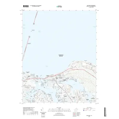
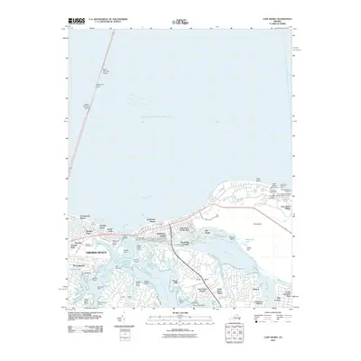 2010 Cape Henry2010 Print · USGSCovers Linkhorn Shores, including Baylake Pines, Broad Bay Colony, and other nearby areas
 - 2013 Map of Cape Henry, 2013 Print
 2013 Cape Henry2013 Print · USGSCovers Linkhorn Shores, including Baylake Pines, Broad Bay Colony, and other nearby areas
 - 2016 Map of Cape Henry, 2016 Print
 2016 Cape Henry2016 Print · USGSCovers Linkhorn Shores, including Baylake Pines, Broad Bay Colony, and other nearby areas
 - 2019 Map of Cape Henry, 2019 Print
 2019 Cape Henry2019 Print · USGSCovers Linkhorn Shores, including Baylake Pines, Broad Bay Colony, and other nearby areas
 - 2022 Map of Cape Henry, 2022 Print
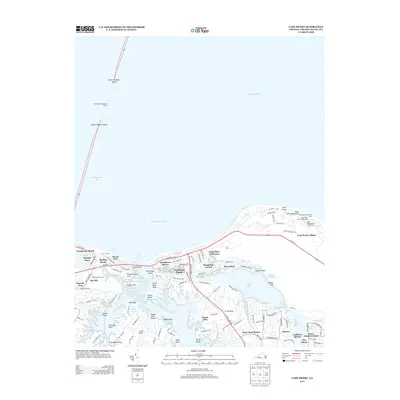
 2022 Cape Henry2022 Print · USGSThe Virginia coast at Cape Henry is captured here in a period of modern maturity, where tidal bays meet established suburban neighborhoods. Trace local landmarks like the Chesapeake Bay Bridge-Tunnel and historical areas like Thoroughgood or Church Point.
End of results
Showing maps 1-13 of 13
Top cities near Linkhorn Shores
Frequently asked questions
- What are the different types of historical maps available for Linkhorn Shores?
- What is the oldest map of Linkhorn Shores?
- Where can I purchase historical maps of Linkhorn Shores for my home or office?
- Where can I download high-res historical maps of Linkhorn Shores?
- Are there historical topographic maps available for Linkhorn Shores?
- Is there historical aerial imagery available for Linkhorn Shores?
- Where are historical maps of Linkhorn Shores sourced from?