1960s Maps of Shenandoah Shores, Virginia
Explore 2 historic maps of Shenandoah Shores from the 1960s. These maps offer a rare glimpse into what life looked like during the 1960s — showing old roads, neighborhoods, homes, and landmarks that have changed or disappeared over time.
Whether you're researching your family's past, planning a metal detecting trip, or studying how Shenandoah Shores's landscape evolved across the 1960s, these high-resolution maps are a powerful tool for exploring the history of this region.
- Focus on a specific era: All maps on this page are from the 1960s, giving you a focused view of this time period.
- See what’s changed: Compare century-old streets, trails, and buildings to today's modern landscape using overlays and satellite layers.
- Research with precision: Use these maps for genealogy, historical research, land use analysis, or educational projects.
- View, download, or print: Maps are fully viewable online in high resolution, and can be downloaded or printed for your own records.
Start exploring Shenandoah Shores's history through authentic maps from the 1960s. This is your window into the past.
Shenandoah Shores, VA maps
(2)- 1966 Map of Linden, 1968 Print
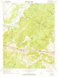 1966 Linden1968 Print · USGSThe Blue Ridge mountain passes of Warren and Fauquier counties are captured here in the mid-1960s. Genealogists and hikers can trace the Appalachian Trail across Blue Mountain or locate old community centers like Linden, Markham, and Mt Paran Ch.5 unique versions available
 - 1967 Map of Front Royal, 1968 Print
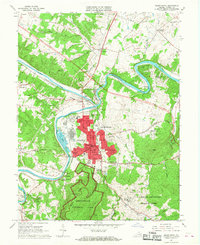 1967 Front Royal1968 Print · USGSFront Royal and the Shenandoah forks were centerpieces of Warren County life in the late sixties. Genealogists and historians can trace family locations near Viscose City, Prospect Hill Cem, and the grounds of Randolph Macon Military Academy.4 unique versions available
End of results
Showing maps 1-2 of 2
Top cities near Shenandoah Shores
- Winchester historical maps
- Front Royal historical maps
- Strasburg historical maps
- Berryville historical maps
- Shenandoah Farms historical maps
- Stephens City historical maps
See more
Frequently asked questions
- What are the different types of historical maps available for Shenandoah Shores?
- What is the oldest map of Shenandoah Shores?
- Where can I purchase historical maps of Shenandoah Shores for my home or office?
- Where can I download high-res historical maps of Shenandoah Shores?
- Are there historical topographic maps available for Shenandoah Shores?
- Is there historical aerial imagery available for Shenandoah Shores?
- Where are historical maps of Shenandoah Shores sourced from?