Old Maps of Weber, Washington
Explore 7 old maps of Weber, spanning from 1925 to today. These high-resolution historic maps reveal how streets, neighborhoods, landmarks, and natural features evolved over time — perfect for genealogy, metal detecting, research, and local history exploration.
What you can do with these maps:
- See how Weber changed over time: Compare historical maps to modern-day views to trace roads, homesites, rail lines & more.
- View detailed metadata: Each map includes creators, publishers, year, scale, and archive source.
- Overlay maps with satellite & LiDAR: Visualize the past alongside modern tools to explore terrain & human change.
- Trusted historical sources: Maps sourced from the USGS, Library of Congress, and other archives.
- Access maps your way: View online, download high-res files, or order prints for personal or research use.
Start exploring old maps of Weber to uncover forgotten places, hidden landmarks, and the deep history beneath your feet.
Weber, WA maps
(7)- 1925 Map of Schrag
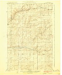 1925 Schrag1925 Print · USGSAdams County’s high desert plateau comes alive in the mid-twenties, showing a landscape of scattered grain elevators and family-named landmarks. Trace early rail life through Batum and Schrag, or locate rural schoolhouses like High Valley School and the Janke School.2 unique versions available
 - 1953 Map of Ritzville, 1966 Print
 1953 Ritzville1966 Print · USGSEastern Washington was undergoing a massive agricultural and industrial transformation in the mid-fifties as irrigation from the Grand Coulee Dam reached the plateau. Researchers can trace the mid-century rail network of the Great Northern and locate vital local sites like Larson Air Force Base and Odessa.3 unique versions available
 - 1959 Map of Ritzville
 1959 Ritzville1959 Print · USGSEastern Washington in the late fifties reveals a landscape transformed by massive irrigation projects and postwar growth. Genealogists and historians can trace rail-line communities from Ritzville to Davenport and locate landmarks like Larson Air Force Base and Telford Station.
 - 1965 Map of Ritzville
 1965 Ritzville1965 Print · USGSCentral Washington during the mid-sixties shows a landscape shaped by massive irrigation projects and the Cold War. Genealogists and historians can trace rail-town life and military presence through Ephrata Air Base, the Telford Station, and local schools.
 - 1967 Map of Weber, 1970 Print
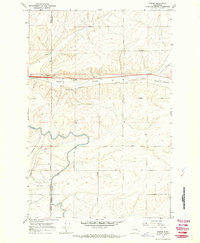 1967 Weber1970 Print · USGSLate 1960s Adams County comes into focus as the irrigation of the Columbia Basin transforms the dry coulees. Researchers can trace family-named routes like Urquhart Road, the rail siding at Schaeffer Spur, and the path of the East Low Canal.2 unique versions available
 - 1982 Map of Ritzville, 1983 Print
 1982 Ritzville1983 Print · USGSEastern Washington's scabland landscape is captured here in the early eighties as a network of rail-towns and coulees. Researchers can trace the BURLINGTON NORTHERN route through Odessa, Lamona, and Ritzville or locate landmarks like Sprague Lake and Karakul Hills.
 - 2023 Map of Weber, 2023 Print
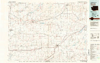
 2023 Weber2023 Print · USGSCentral Washington's agricultural heartland is documented here in the early 2020s, centered on the Weber settlement. Trace the intersection of natural features like Farrier Coulee with man-made infrastructure such as the East Low Canal.
End of results
Showing maps 1-7 of 7
Top cities near Weber
Frequently asked questions
- What are the different types of historical maps available for Weber?
- What is the oldest map of Weber?
- Where can I purchase historical maps of Weber for my home or office?
- Where can I download high-res historical maps of Weber?
- Are there historical topographic maps available for Weber?
- Is there historical aerial imagery available for Weber?
- Where are historical maps of Weber sourced from?