Old Maps of Holden Village, Washington
Explore 10 old maps of Holden Village, spanning from 1902 to today. These high-resolution historic maps reveal how streets, neighborhoods, landmarks, and natural features evolved over time — perfect for genealogy, metal detecting, research, and local history exploration.
What you can do with these maps:
- See how Holden Village changed over time: Compare historical maps to modern-day views to trace roads, homesites, rail lines & more.
- View detailed metadata: Each map includes creators, publishers, year, scale, and archive source.
- Overlay maps with satellite & LiDAR: Visualize the past alongside modern tools to explore terrain & human change.
- Trusted historical sources: Maps sourced from the USGS, Library of Congress, and other archives.
- Access maps your way: View online, download high-res files, or order prints for personal or research use.
Start exploring old maps of Holden Village to uncover forgotten places, hidden landmarks, and the deep history beneath your feet.
Holden Village, WA maps
(10)- 1902 Map of Stehekin, 1955 Print
 1902 Stehekin1955 Print · USGSLake Chelan and the North Cascades are captured here at the dawn of the twentieth century, during a period of remote mountain development. Genealogists and historians can trace early settlements at Stehekin, Lucerne, and Gilbert, along with the route of the Holden Railroad.2 unique versions available
 - 1904 Map of Stehekin
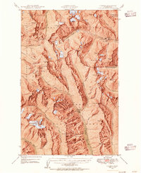
 1904 Stehekin1904 Print · USGSThe northern reaches of Lake Chelan are captured here at the turn of the century, showing a wilderness being shaped by early mountain outposts and mining. Genealogists and researchers can trace remote sites like Gilbert and Holden, or the unique path of the Holden Railroad.5 unique versions available
 - 1944 Map of Holden, 1955 Print
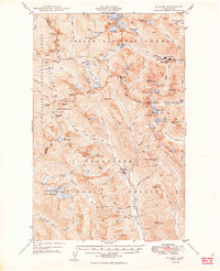
 1944 Holden1955 Print · USGSThe northern Cascades of the 1940s come into focus through this survey of the high alpine region between Chelan and Snohomish counties. Researchers can trace the legacy of remote mining at the Holden Mine and find the site of the old Trinity settlement.7 unique versions available
 - 1949 Map of Holden
 1949 Holden1949 Print · USGSThe high Cascades of Chelan County are documented here during the post-war era of active mountain mining and alpine exploration. Researchers can trace the industrial footprint of the Holden Mine and Glacier Peak Mines alongside high-country camps like McKenzie Camp.3 unique versions available
 - 1955 Map of Concrete, 1967 Print
 1955 Concrete1967 Print · USGSThe North Cascades in the mid-fifties reveal a landscape of deep glacier-fed lakes and riverside timber towns. You can trace the Great Northern rail lines through Granite Falls or locate remote outposts like Stehekin and Marblemount along the Skagit and Chelan waters.
 - 1958 Map of Concrete
 1958 Concrete1958 Print · USGSThe North Cascades and Skagit Valley are captured here in the late fifties, showing a landscape defined by glacier-carved peaks and river-bottom settlements. Genealogists and historians can locate remote mining sites like Holden Mine and mountain outposts such as Stehekin, Marblemount, and Mazama.2 unique versions available
 - 1962 Map of Concrete
 1962 Concrete1962 Print · USGSThe Northern Cascades in the early sixties reveal a landscape of high alpine peaks and deep river valleys before the modern park era. Genealogists and historians can trace rail-and-river towns like Concrete, Darrington, and Stehekin, alongside industry at the Holden Mine.
 - 1988 Map of Holden
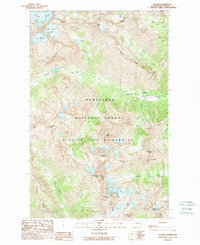 1988 Holden1988 Print · USGSThe high Chelan Mountains and the mining settlement of Holden are captured here in the late eighties. Researchers can trace the industrial landscape of the Mine and Tailings alongside prominent peaks like Seven Fingered Jack and Mt Maude.2 unique versions available
 - 2004 Map of Holden, 2008 Print
 2004 Holden2008 Print · USGSThe mining community of Holden is captured here in the early 2000s, surrounded by the high peaks of the Chelan Mountains. Researchers can trace industrial footprints at the Mine and Tailings alongside the glacial waters of Railroad Creek.
 - 2023 Map of Holden, 2023 Print
 2023 Holden2023 Print · USGSThe high Cascades of Chelan County appear here in the early twenty-first century, showcasing a landscape of glaciers and alpine peaks. Hikers and researchers can trace the intricate network of routes like the Lower Railroad Creek Trl leading past Company Glacier and the Ice Lakes.
End of results
Showing maps 1-10 of 10
Frequently asked questions
- What are the different types of historical maps available for Holden Village?
- What is the oldest map of Holden Village?
- Where can I purchase historical maps of Holden Village for my home or office?
- Where can I download high-res historical maps of Holden Village?
- Are there historical topographic maps available for Holden Village?
- Is there historical aerial imagery available for Holden Village?
- Where are historical maps of Holden Village sourced from?