1940s Maps of Holden Village, Washington
Explore 2 historic maps of Holden Village from the 1940s. These maps offer a rare glimpse into what life looked like during the 1940s — showing old roads, neighborhoods, homes, and landmarks that have changed or disappeared over time.
Whether you're researching your family's past, planning a metal detecting trip, or studying how Holden Village's landscape evolved across the 1940s, these high-resolution maps are a powerful tool for exploring the history of this region.
- Focus on a specific era: All maps on this page are from the 1940s, giving you a focused view of this time period.
- See what’s changed: Compare century-old streets, trails, and buildings to today's modern landscape using overlays and satellite layers.
- Research with precision: Use these maps for genealogy, historical research, land use analysis, or educational projects.
- View, download, or print: Maps are fully viewable online in high resolution, and can be downloaded or printed for your own records.
Start exploring Holden Village's history through authentic maps from the 1940s. This is your window into the past.
Holden Village, WA maps
(2)- 1944 Map of Holden, 1955 Print
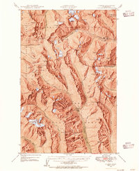 1944 Holden1955 Print · USGSThe northern Cascades of the 1940s come into focus through this survey of the high alpine region between Chelan and Snohomish counties. Researchers can trace the legacy of remote mining at the Holden Mine and find the site of the old Trinity settlement.7 unique versions available
 - 1949 Map of Holden
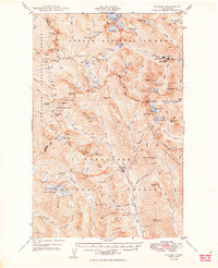 1949 Holden1949 Print · USGSThe high Cascades of Chelan County are documented here during the post-war era of active mountain mining and alpine exploration. Researchers can trace the industrial footprint of the Holden Mine and Glacier Peak Mines alongside high-country camps like McKenzie Camp.3 unique versions available
End of results
Showing maps 1-2 of 2
Frequently asked questions
- What are the different types of historical maps available for Holden Village?
- What is the oldest map of Holden Village?
- Where can I purchase historical maps of Holden Village for my home or office?
- Where can I download high-res historical maps of Holden Village?
- Are there historical topographic maps available for Holden Village?
- Is there historical aerial imagery available for Holden Village?
- Where are historical maps of Holden Village sourced from?