1900s (20th Century) Maps of Malaga, Washington
Explore 7 historic maps of Malaga from the 1900s (20th Century). These maps offer a rare glimpse into what life looked like during the 1900s — showing old roads, neighborhoods, homes, and landmarks that have changed or disappeared over time.
Whether you're researching your family's past, planning a metal detecting trip, or studying how Malaga's landscape evolved across the 1900s, these high-resolution maps are a powerful tool for exploring the history of this region.
- Focus on a specific era: All maps on this page are from the 1900s, giving you a focused view of this time period.
- See what’s changed: Compare century-old streets, trails, and buildings to today's modern landscape using overlays and satellite layers.
- Research with precision: Use these maps for genealogy, historical research, land use analysis, or educational projects.
- View, download, or print: Maps are fully viewable online in high resolution, and can be downloaded or printed for your own records.
Start exploring Malaga's history through authentic maps from the 1900s. This is your window into the past.
Malaga, WA maps
(7)- 1912 Map of Malaga
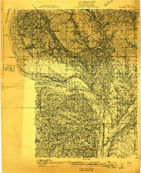 1912 Malaga1912 Print · USGSCentral Washington's river-driven development is on display here just before the era of major hydroelectric projects. Genealogists and historians can trace an incredible density of early schools like Lower Stemilt School and settlements like Malaga and Vulcan.2 unique versions available
 - 1914 Map of Malaga
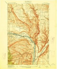 1914 Malaga1914 Print · USGSCentral Washington ranching and rail life are captured here just before World War I, centered on the Columbia River corridor. Genealogists and local historians can locate early homesteads and landmarks like the Sheehan Ranch, Malaga, and Liberty School.3 unique versions available
 - 1920 Map of Colockum Pass
 1920 Colockum Pass1920 Print · USGSKittitas and Douglas counties are shown during a time of river ferries and mountain ranching. You can trace early schoolhouse locations like Whisky Dick School and follow the old Trinidad Ferry route across the Columbia River.
 - 1922 Map of Colockum Pass
 1922 Colockum Pass1922 Print · USGSEastern Washington ranching and river commerce are captured here just after the Great War, showing a landscape of high mountain passes and vital Columbia River crossings. Genealogists can trace family homesteads like Sheridan Ranch and local rural landmarks including Whisky Dick School and the Trinidad Ferry.2 unique versions available
 - 1957 Map of Wenatchee, 1973 Print
 1957 Wenatchee1973 Print · USGSThe northern Cascades and Columbia River valley appear here in the mid-fifties, showing the region's critical rail and transit corridors. Researchers can trace the routes of the Great Northern RR and Milwaukee Road through settlements like Skykomish, Baring, and Dryden.2 unique versions available
 - 1966 Map of Malaga, 1968 Print
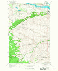 1966 Malaga1968 Print · USGSSettled along the Columbia River in the mid-sixties, this area shows a transition from riverfront rail hubs to high ridge country. Trace the Great Northern tracks through Malaga or explore the remote Colockum Research Unit Washington State University.2 unique versions available
 - 1975 Map of Wenatchee, 1977 Print
 1975 Wenatchee1977 Print · USGSCentral Washington in the mid-seventies shows a landscape of deep mountain valleys and bustling river towns. Trace the industrial and agricultural backbone of the region along the Yakima River and Columbia River, from the mining history of Roslyn to the rail hubs at Cle Elum and Appleyard.
End of results
Showing maps 1-7 of 7
Top cities near Malaga
Frequently asked questions
- What are the different types of historical maps available for Malaga?
- What is the oldest map of Malaga?
- Where can I purchase historical maps of Malaga for my home or office?
- Where can I download high-res historical maps of Malaga?
- Are there historical topographic maps available for Malaga?
- Is there historical aerial imagery available for Malaga?
- Where are historical maps of Malaga sourced from?