Old Maps of Mount Pleasant, Washington
Explore 12 old maps of Mount Pleasant, spanning from 1918 to today. These high-resolution historic maps reveal how streets, neighborhoods, landmarks, and natural features evolved over time — perfect for genealogy, metal detecting, research, and local history exploration.
What you can do with these maps:
- See how Mount Pleasant changed over time: Compare historical maps to modern-day views to trace roads, homesites, rail lines & more.
- View detailed metadata: Each map includes creators, publishers, year, scale, and archive source.
- Overlay maps with satellite & LiDAR: Visualize the past alongside modern tools to explore terrain & human change.
- Trusted historical sources: Maps sourced from the USGS, Library of Congress, and other archives.
- Access maps your way: View online, download high-res files, or order prints for personal or research use.
Start exploring old maps of Mount Pleasant to uncover forgotten places, hidden landmarks, and the deep history beneath your feet.
Mount Pleasant, WA maps
(12)- 1918 Map of Port Angeles
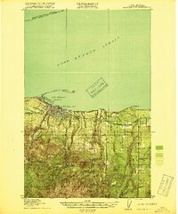 1918 Port Angeles1918 Print · USGSThe northern Olympic Peninsula comes to life in the years following the Great War, showing a landscape defined by maritime trade and logging. Genealogists and historians can locate early landmarks like Reeveton, the Ennis Creek Ranger Station, and several rural schools including Fairview School.4 unique versions available
 - 1941 Map of Port Angeles, 1958 Print
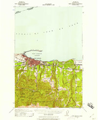 1941 Port Angeles1958 Print · USGSPort Angeles and its harbor stood as a gateway to the Olympic Peninsula in the early 1940s, balancing industrial shipping with rugged forest terrain. Genealogists and historians can locate family landmarks like Krajewski Ranch, the Fairview Sch, and the Angeles L H at the end of Ediz Hook.
 - 1956 Map of Morse Creek, 1958 Print
 1956 Morse Creek1958 Print · USGSThe Clallam County coast and the foothills of the Olympic Mountains are captured here in the mid-fifties as rural ranching and timber communities flourished. Researchers can trace family history through the Cameron Homestead, locate the old Fairview School, or find vanished landmarks like the Drive-in Theater.
 - 1957 Map of Victoria, 1960 Print
 1957 Victoria1960 Print · USGSThe San Juan Islands and the North Cascades coastline are shown in detail during the late fifties, a period of significant military and industrial presence. Researchers can trace historic rail lines like the Great Northern or locate sites such as the Whidbey Island Naval Air Sta and Friday Harbor.4 unique versions available
 - 1961 Map of Morse Creek
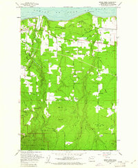 1961 Morse Creek1961 Print · USGSClallam County’s rugged coastline and timbered interior are captured here in the early sixties, showing the reach of the Milwaukee Road. Genealogists and local historians can trace the Cameron Homestead, Fairview Sch, and the Port Angeles Dam.4 unique versions available
 - 1961 Map of Port Angeles, 1962 Print
 1961 Port Angeles1962 Print · USGSPort Angeles and the Olympic coastline are captured here in the early sixties, showing the city's harbor-driven industry and the nearby wilderness. Researchers can trace family ranchlands like Hambly Ranch, find local landmarks like Fairview Sch, or locate the Cameron Homestead.3 unique versions available
 - 1979 Map of Port Angeles
 1979 Port Angeles1979 Print · USGSThe northern Olympic Peninsula and southern Vancouver Island are captured here in the late seventies. Family historians can trace the rail networks of the Esquimalt and Nanaimo Railway or locate old coastal settlements like Sooke, Joyce, and Agnew.
 - 2011 Map of Morse Creek, 2011 Print
 2011 Morse Creek2011 Print · USGSCovers Mount Pleasant, including R Corner, Little Oklahoma, and other nearby areas
 - 2014 Map of Morse Creek, 2014 Print
 2014 Morse Creek2014 Print · USGSCovers Mount Pleasant, including R Corner, Little Oklahoma, and other nearby areas
 - 2017 Map of Morse Creek, 2017 Print
 2017 Morse Creek2017 Print · USGSCovers Mount Pleasant, including R Corner, Little Oklahoma, and other nearby areas
 - 2020 Map of Morse Creek, 2020 Print
 2020 Morse Creek2020 Print · USGSCovers Mount Pleasant, including R Corner, Little Oklahoma, and other nearby areas
 - 2023 Map of Morse Creek, 2023 Print
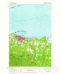
 2023 Morse Creek2023 Print · USGSThe Olympic Peninsula shoreline and its rugged interior foothills are charted here in recent detail, showing the area east of Port Angeles. Researchers can locate the Blue Mountain Cem, the community of Little Oklahoma, and numerous family landmarks like Maletti Hill.
End of results
Showing maps 1-12 of 12
Top cities near Mount Pleasant
Frequently asked questions
- What are the different types of historical maps available for Mount Pleasant?
- What is the oldest map of Mount Pleasant?
- Where can I purchase historical maps of Mount Pleasant for my home or office?
- Where can I download high-res historical maps of Mount Pleasant?
- Are there historical topographic maps available for Mount Pleasant?
- Is there historical aerial imagery available for Mount Pleasant?
- Where are historical maps of Mount Pleasant sourced from?