Old Maps of Ozette, Washington
Explore 12 old maps of Ozette, spanning from 1935 to today. These high-resolution historic maps reveal how streets, neighborhoods, landmarks, and natural features evolved over time — perfect for genealogy, metal detecting, research, and local history exploration.
What you can do with these maps:
- See how Ozette changed over time: Compare historical maps to modern-day views to trace roads, homesites, rail lines & more.
- View detailed metadata: Each map includes creators, publishers, year, scale, and archive source.
- Overlay maps with satellite & LiDAR: Visualize the past alongside modern tools to explore terrain & human change.
- Trusted historical sources: Maps sourced from the USGS, Library of Congress, and other archives.
- Access maps your way: View online, download high-res files, or order prints for personal or research use.
Start exploring old maps of Ozette to uncover forgotten places, hidden landmarks, and the deep history beneath your feet.
Ozette, WA maps
(12)- 1935 Map of Ozette Lake, 1957 Print
 1935 Ozette Lake1957 Print · USGSCoastal Clallam County at the mid-thirties reveals a landscape of isolated homesteads and ancient village sites along the Pacific. Researchers can locate family landmarks like Pete Rooses Ranch and the Old Cemetery near the Ozette Indian Reservation.2 unique versions available
 - 1942 Map of Ozette Lake
 1942 Ozette Lake1942 Print · USGSThe Olympic Peninsula's remote coastal frontier is preserved here during the early war years, centered on the waters of Ozette Lake. Researchers can trace early family homesteads like Rooses Prairie and locate the Abandoned Indian Village at Cape Alava.
 - 1953 Map of Cape Flattery, 1968 Print
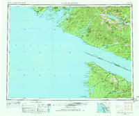 1953 Cape Flattery1968 Print · USGSThe maritime border between Washington and British Columbia comes into sharp focus during the mid-century, detailing the remote coastal reaches of both nations. Researchers can trace the layout of the Makah Indian Res and fishing outposts like Sekiu and Port Renfrew.2 unique versions available
 - 1956 Map of Ozette Lake, 1960 Print
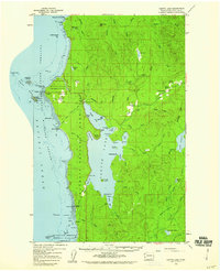 1956 Ozette Lake1960 Print · USGSThe rugged Pacific coast and Ozette Lake region are captured in the mid-1950s, showing a landscape of tribal lands and isolated homesteads. Researchers can locate the Indian Village (Site), the Old Cemetery, and family sites like Iverson Ranch.4 unique versions available
 - 1963 Map of Cape Flattery
 1963 Cape Flattery1963 Print · USGSThe Pacific Northwest coast and the entrance to the Puget Sound are captured in detail during the early 1960s. Researchers can trace remote coastal settlements and tribal lands including the Makah Indian Reserve, Port Renfrew, and the timber town of Sekiu.
 - 1984 Map of Ozette
 1984 Ozette1984 Print · USGSThe westernmost edge of the Olympic Peninsula is captured here in the mid-1980s, where the Ozette Indian Reservation meets the Pacific. Trace local history through the Old RR Grade, the Foot Trail to Cape Alava, and family-named landmarks like Rooses Prairie.
 - 1986 Map of Cape Flattery, 1987 Print
 1986 Cape Flattery1987 Print · USGSThe tip of the Olympic Peninsula and the waters of the Strait of Juan de Fuca are captured here in the mid-eighties. Researchers can trace tribal lands like the Makah Indian Reservation, the remote Old Royal settlement, and maritime landmarks like Cemetery Point.
 - 2011 Map of Ozette, 2011 Print
 2011 Ozette2011 Print · USGSCovers Ozette, including Clallam County, United States, and other nearby areas
 - 2014 Map of Ozette, 2014 Print
 2014 Ozette2014 Print · USGSCovers Ozette, including Clallam County, United States, and other nearby areas
 - 2017 Map of Ozette, 2017 Print
 2017 Ozette2017 Print · USGSCovers Ozette, including Clallam County, United States, and other nearby areas
 - 2020 Map of Ozette, 2020 Print
 2020 Ozette2020 Print · USGSCovers Ozette, including Clallam County, United States, and other nearby areas
 - 2023 Map of Ozette, 2023 Print
 2023 Ozette2023 Print · USGSThe Olympic coast remains a wild frontier in this modern survey of Washington's westernmost edge. Researchers can trace the paths of the Cape Alava Trl and Sand Point Trl through historic clearings like Ahlstroms Prairie and Rooses Prairie.
End of results
Showing maps 1-12 of 12
Top cities near Ozette
Frequently asked questions
- What are the different types of historical maps available for Ozette?
- What is the oldest map of Ozette?
- Where can I purchase historical maps of Ozette for my home or office?
- Where can I download high-res historical maps of Ozette?
- Are there historical topographic maps available for Ozette?
- Is there historical aerial imagery available for Ozette?
- Where are historical maps of Ozette sourced from?